Virginia’s Historic Triangle is really America’s heart. Here, in the early 1600s, Jamestown became the first permanent English settlement in North America. Despite having made a poor choice for the selection of this settlement, it would become the first step of many.
When it became apparent that the geography of the Jamestown settlement was not suited for a settlement, the new colony moved further inland away from the swampy lands to the more fertile ground where crops could be planted, and the land could be developed. Here Williamsburg was founded and it became the capital of the new Virginia colony.
The small town became the heart of a revolution that would ultimately shake the world. Leading up to that revolution, young men, that would later become known as the founding fathers, would debate the merits of democracy and would eventually risk their lives when they raised their voices against the King and country, urging the citizens to support a revolution.
Once that revolution took shape, it would be ultimately decided just a few miles down the road at the small seaport of Yorktown. Here the most powerful army in the world would be outwitted and outmatched in a final conflict that would ultimately result in the British surrender and the recognition by the world of the brand new United States of America.
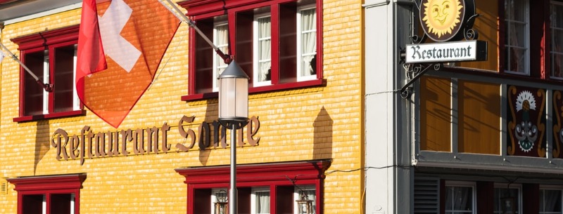
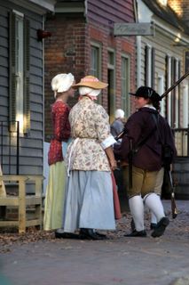
Historic Williamsburg
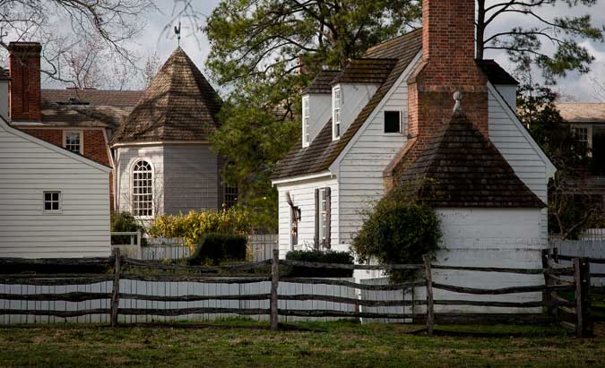
Colonial Williamsburg is an eighteenth-century community restored to the time when it was the center of Britain’s largest colony in the New World.
Williamsburg is where a number of America’s patriots lived at one time including George Washington, Thomas Jefferson, Richard Henry Lee, and Benjamin Harrison, all signers of the Declaration of Independence except for George Washington who was fighting the British Army in New York at the time.
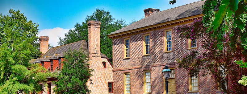
Williamsburg today represents our country’s beginnings. It was here that many of the concepts of freedom were openly and often fiercely debated. For all intents and purposes, the streets of Colonial Williamsburg, look much like Williamsburg of 1775 looked. Great care has gone into the myriad details including extensive research of historical records and documents to make the village as authentic as possible.
The orientation walk is designed to help first-time guests to better plan their visit. Volunteers and costumed staff lead the 30-minute walks and provide guests with the latest information on programs, dining, and shopping options. Guests also get an overview of the 18th-century community while learning about the ongoing restoration of Williamsburg. Included in all Historic Area or Museum admission passes.
Read More Historic Williamsburg
Yorktown
If you like seeing historic places, old canon including mortars, howitzers and field pieces, you’ll love the Yorktown Battlefield. This is where the American Army, thanks to helping from the French, finally put together a massive and decisive victory over the professional British Army and Navy. This one battle would eventually lead to the British departing from the colonies, giving the Americans their long-sought freedom from British control.
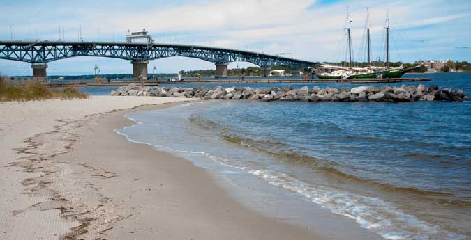
The small town of Yorktown had become the key in this world war of superpowers. In the early days of settlement, Yorktown was a major shipping port where Virginia farmers could ship their tobacco harvest back to England and Europe. It was an ideal location. The deep water allowed for sailing vessels to easily maneuver in the wide stretch of water, but it was still protected from hurricanes that might travel north along the coast. Over the years, the tobacco farms began to fail and Yorktown ceased being the major seaport it once was. That was how Cornwallis found it in 1781.
Operated by the National Park Service this is where American independence was won. At the visitor center is a film, museum, book shop and battlefield overlook. Highlights of the battle including numerous earthworks, the site of Washington’s Headquarters, Surrender Field and the home to Governor Thomas Nelson, Jr.
Yorktown Driving Tour
A 9-mile self-guided driving tour winds through the cannons and earthworks and markers of the battlefield. Retrace the steps of the allied troops as they took British Redoubts 9 and 10 during a surprise night attack which helped turn the tide toward an Allied victory. At Surrender Field stand on the very site where the British troops laid down their arms on October 19, 1781, and effectively ended the American Revolution.
An informative audio tour provides a narrative from two participants in the battle. The tour gives directions and precautions, plus insights into activities that were going on in 1781. The audio tour is available for purchase at the Yorktown Battlefield Visitor Center museum store. Maps are also available for those who wish to explore the village of Yorktown on foot.
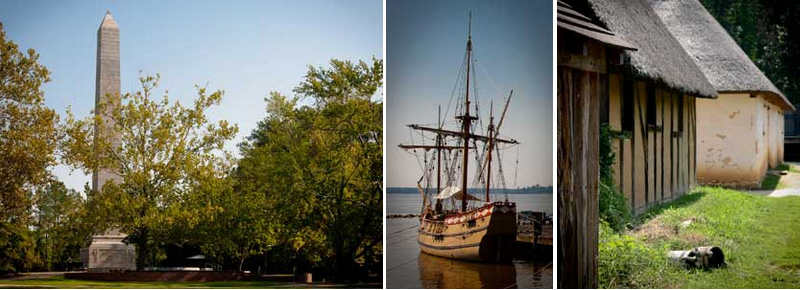
Historic Jamestown
HISTORIC JAMESTOWN is part of the National Park Service and is open to the public with a small admission. That admission gains visitors entrance to the museum and artifacts, the actual Jamestowne historic site, as well as the Colonial Parkway (a one-way loop around the peninsula).
The visitor center has a short film that gives a good overview as well as displays. Leading out from the Visitor Center is a long elevated walkway to the Tercential Monument, the 1607 Fort James site as well as viewing roped archeological digs that are an ongoing part of the historic site. A small cafe is also along the river bank.
Originally known as James Fort which was founded in 1607, it was the first permanent English settlement in what would later become the United States of America. It was established by the London Company. In 1619 the fort was converted to a town. Today there are 2 Jamestown’s that both represent the original colony.
As you drive down Colonial Parkway the first Jamestown you come to is the Jamestown Settlement. This is a full-sized recreated Jamestown. Just down the road is Historic Jamestown that features archeological excavations, recreated structures as they might have appeared exactly where they were in the early 1600s. Both sites charge admission.
 Known as “Historic” Jamestown, this is the actual site where James Fort was built. Surprisingly, the site has only recently undergone an extensive archeological study which continues. The reason for this is that it was assumed based on historical documents that the actual James Fort location had been lost to soil erosion from the James River. Only recently did the fact that the fort was still mostly on land and only a small portion of the fort had been lost.
With a paid admission, you can see the archeology that is ongoing uncovering the actual site where that first permanent settlement was located. It was here that the original capital of the Virginia colony was built until 1676 when, during Bacon’s Rebellion, the capital building was burned to the ground. After that brief conflict, the capital was then moved to what is today known as Williamsburg.
The Historic Jamestown site is jointly administered by the United States National Park Service and The Colonial Williamsburg Foundation.
Public Transportation is available from the Colonial Williamsburg Visitor Center between 9:00 a.m. and 3:30 p.m. daily between April 15 and October 31. This service stops at both the Historic Jamestown site and the Jamestown Settlement location.
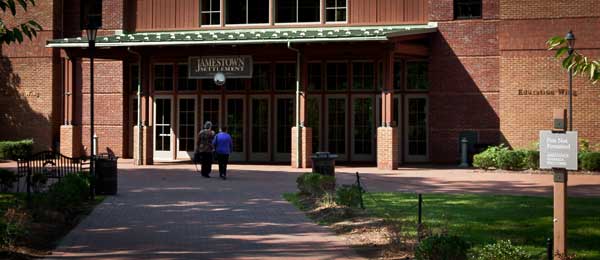
Jamestown Settlement
America’s first permanent English colony. Displays and a film explain history. Replicas of the settler’s ships recreated colonial fort in a Powhatan Indian village. JAMESTOWN SETTLEMENT is a state-operated museum that includes an authentic Powhatan Native Village, 3 – 16th Century ocean-going vessels that visitors can board as they’re docked to a pier jutting out into the James River. There is also a recreated Fort James that has informed interpreters and authentic-looking artifacts that visitors can handle.
The Jamestown Settlement is a recreation of what Jamestown is thought to have looked like, including a small Native American village. There are also 3 reproduction historic ships permanently docked to a pier and available for visitors to board. Before beginning your visit to the outdoor settlement be sure to see the documentary film that runs every 30 minutes in the visitors center. Also, walk through the large exhibition gallery (no photos allowed inside the gallery) that will exit near the trail taking you back to recreated Powhatan Indian village. All visitors are entitled to take a guided tour or join a guided tour already in progress. The guided tours will take you through all of the major sections and include an excellent interpretation of that particular area.
The recreated James Fort has docents on hand that will give a lively interpretation of their colonial job and perhaps give some of the political slants of the day. There are plenty of hands-on activities that the kids will enjoy as well as a musket firing whenever a crowd gathers. Craftsmen are in some of the houses performing tasks.
Jamestown Island Drive
A scenic loop allows visitors to drive, bike, or walk through a preserved section of the island. Along the way visitors may see various wildlife, vistas of the marshy ecosystem that encompasses most of Jamestown Island. Along the route are interpretative signs that provide small snippets of local lore and early inhabitants that help paint a dynamic picture of the island.
James River Plantations
Running parallel to the north bank of the James River is US Highway 5 that comes out of Williamsburg and heads west to Richmond. Along this highway are a number of historic plantations that still operate. Several are open year-round for tourists and may be worth your while to check out while in the Williamsburg area.
Of note are the Berkeley Plantation and Shirley Plantation. Both of these sites are open for guided tours of the house and grounds. Both plantations lay claim to several notable points of history. The Shirley Plantation claims to be Virginia’s First Plantation and was established in 1613. Berkeley Plantation lays claim to being the site of America’s First Thanksgiving (not the Pilgrim thanksgiving) when thanks were given by the crew of the ship Margaret for a safe passage from England on December 4, 1619. Berkeley as the birthplace of William Henry Harrison, the 9th President of the United States.
Although both Berkeley and Shirley Plantations are open to the public, a fee is required to tour the grounds and house. The other plantations along US 5 should be contacted individually to arrange tours.
Colonial Parkway
A visit to Colonial Williamsburg just isn’t complete without taking the very pleasant Colonial Parkway that connects the big-3 colonial sites of Virginia. The highway starts at the Colonial Williamsburg Visitor Center and then splits with one stretch running down to Historic Jamestown and the Jamestown Settlement, and the other section diverting over to Yorktown Battlefield, Yorktown Victory, and the town of Yorktown.
It has been constructed so that for most of the time visitors are on the parkway, they are shielded from most modern-day urban environments making it an enjoyable way of traveling between Jamestown, through Williamsburg and on to Yorktown. The parkway is also an outstanding example of American parkway design. It is maintained by the US Department of the Interior and the National Park Service.
Traffic Rules of the Road
The Colonial Parkway is free of trucks and commercial vehicles except for passenger-carrying buses. The lower speed limits and few exits combine to help preserve the road for tourists and protect wildlife by making it an unattractive short-cut for most local traffic and commuters. The unmarked pavement is made of rounded “river gravel” set in a concrete-mix, providing an unusual earth tone color. Since the Parkway is intended primarily for sightseeing, and only secondarily as a through route to the historic points, there are many pull-offs with markers giving brief descriptions of the view.
The Parkway has no painted traffic lane-marking lines and some stretches are posted “Pass With Care”, but it is important to be vigilant for oncoming traffic which may also pass and share the center of the roadway. The more popular pull-offs are near the James River and York River ends of the parkway, where there are panoramic views across each river. The moderate speed limits and safety (for all creatures) are well-protected by National Park Service law enforcement rangers. Despite a federal policy instituted late in the 20th century of requiring user fees at many National Parks and Monuments, the Colonial Parkway has remained toll-free.
Freedom Park
Located on the west side of Williamsburg at Centerville and Longhill Roads is the new Freedom Park. Although this is not part of the historical Williamsburg of the 18th Century, it is directly related to early 19th Century Black-Americans that were former slaves that obtained their freedom and given the opportunity to make a living using trade skills.
The area was known as Hot Water and was part of the Green spring plantation created by Royal Governor William Berkeley in 1652. After Berkeley’s death, the Hot Water tract was inherited by the Ludwell and Lee families. In 1796 the property was inherited by 18-year-old William Ludwell Lee who would die just 7 years later. Before his death, however, he changed his will to specifically free his slaves when they reached the age of 18 and were allowed to live on the property for 10 years at no charge in houses that were to be built on a special tract of land. This tract of land and the settlement at Centerville became one of Virginia’s early free black settlements.
Today, some 700 acres located about 5 miles north of Historic Green Spring is Freedom Park, located on land that was known then as the Hot Waters, a subsidiary farm of Green Spring. It was here that the freed slaves were given houses and land at no cost. Although it wasn’t perfect, it was a new beginning.
Today Freedom Park has 3 historically accurate cabins that are open to the public at no charge. Each cabin represents a typical income level for people living in the area. The area was occupied between 1804 and 1860.
Biking / Hiking Trails
The 600-acre site also features some 2 miles of hiking trails and 20 miles of mountain bike trails that wind through the property that includes creeks, meadows, and forests. The bike trails were designed by the Eastern Virginia Mountain Bike Association, however, they are only open during good weather conditions to prevent damage to the newly made trails.