The Trail Ridge Road offers breathtaking views of the splendid scenery of the Rocky Mountain National Park. It has derived its name from its close proximity to the historic pathways that were used by the native people to cross the Rocky Mountains. With a maximum elevation of nearly 12,183 ft and over 8 miles above 11,000 ft, this road is higher than any mountain in the Yellowstone or Glacier National Parks. In fact, it is the highest motorway in the United States with a maximum grade of about 7 %. The minimum radius is nearly 200 ft (60 m) on the blind curves and 100 ft for open curves. Besides, the Road is a two-lane with a 22 ft roadbed and 3 ft ditches in the cut sections.
This is what the scenery around Trail Ridge Road in Rocky Mountain National Park looks like during the fall season just before the road closes for the year! As the temperatures cool down, the snow begins to build up, and eventually, you’ll have to wait until May or June of the following year to drive across the summit once again.
The construction of the Trail Ridge Road began in 1929 and it was completed in July 1932. This Road was designed mainly to overcome the deficiencies of the Fall River Road and to provide broader curves, gentle grades, and a better variety of scenic experiences. The first section of the Road, Deer Ridge to Fall River Pass, stretches for nearly 17.2 miles (27.6 km). It was in the year 1938 that the road was finally extended up to the Grand Lake.
The lower part of the Trail Ridge Road is open to the public throughout the year while the central portion is open only from late May through mid-October. However, the road may close periodically owing to the unfavorable weather conditions. The central part of the Road cuts through open alpine tundra and provides some of the best vistas of the panoramic mountains in the Nation. The spacious stone-wall turnouts on major curves offer ample space for visitors to take in the views. The best time to visit the Trail Ridge Road is at night when one can clearly see the Milky Way, one of nature’s greatest light shows. You can gaze at billions and billions of stars including Sirius, Virgo, Orion, North Star, and the Big Dipper.
Estes Park
I wouldn’t be surprised if someone told me that The Sound of Music had been filmed in Estes Park—the skipping through the alpine meadows section, not the running from the Nazis bit. Nestled at the base of white-crested mountains, the town is home to fewer than six thousand people and about 2,400 elks. Estes Park is an outdoor playground, offering fishing, hiking, rock climbing, and snowshoeing opportunities. There is also a small art scene and free musical events in summer, at the Performance Park Amphitheater. It’s a good home base.
From Estes Park, take highway 36 (helpfully called Park Entrance Road) into Rocky Mountain National Park. Travel through a grassy valley, edged by the stern, gray peaks that remind you of your complete insignificance. There are places to pull over and absorb the scale of nature’s giants. Settle down on a bench–it may take a while.
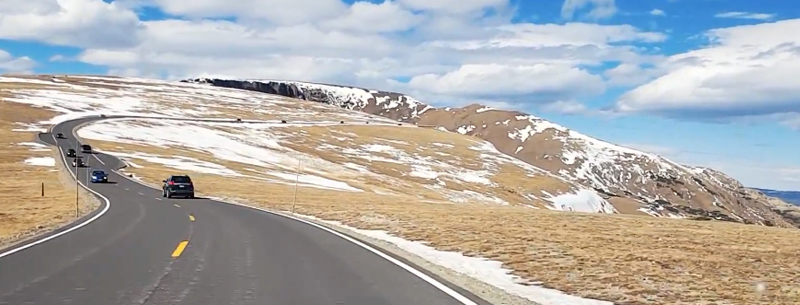
Then the 36 turns into highway 34, Trail Ridge Road, which is the highest continually paved road in the country. This route is also one of only ten recognized as America’s Byways. (Another white-knuckle drive is the Million Dollar Highway).
You quickly leave the valley floor behind, as you ascend 4000 feet, one switchback at a time. Park at the pullout two-thirds of the way to the top, for a chance to snap pictures of the mountains stretching across the horizon: the rocky summits melt into dark green ponderosa pines and Douglas firs, then your eye sinks down to the meadows, impossibly far below.
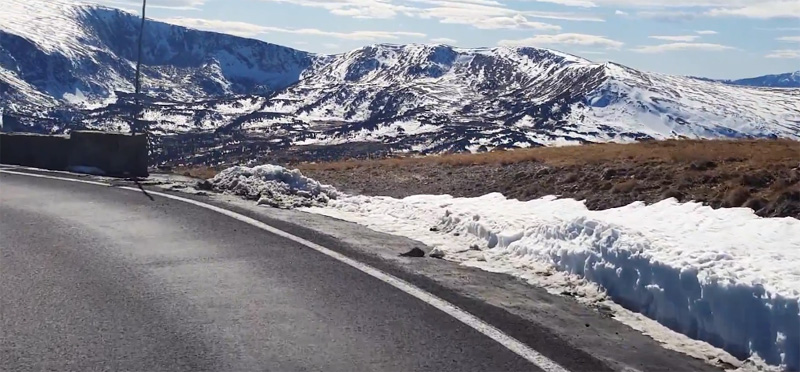
If you are a nervous driver or suffer from acrophobia, this is the point at which you might want to turn around. You’ve had a chance to admire the Rockies, which is why you came in the first place. Otherwise, continue climbing up for eleven miles, at about 11,500 feet in elevation. There is no guardrail to your right, but that’s okay because the road hugs the side of the mountain, so the car is somewhat protected from the brutal, gusting winds. Then it happens. The mountain disappears.
You are so high up that you are actually driving along the ridge, with drop-offs on either side, no hint of a guardrail, and the aforementioned winds whipping by. The National Parks Service compares conditions to those found in the Canadian or Alaskan Arctic. Yes, the Arctic! It would be really handy to be in one of those James Bond vehicles that neatly transform into a boat when in water—except you’d need one that was a part airplane, or at least had a giant parachute attached.
At the Top
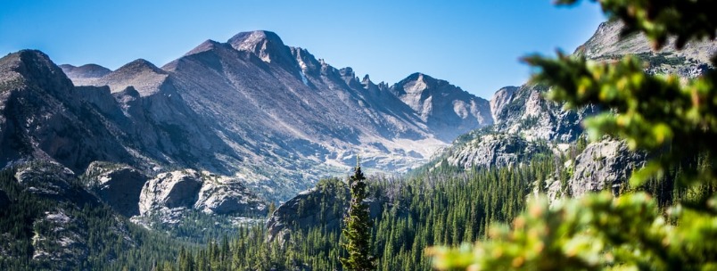
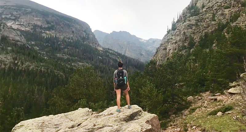
Celebrate! You made it to the top, which is at an impressive 12,183 feet. To check out the visitor’s center, make a right onto Old Fall River Rd. Otherwise park and explore the alpine tundra—just be careful to stay on the trail as this is an extremely delicate ecosystem. There is also an opportunity to admire the view in the opposite direction.
I found it so stunning that I jogged to the lookout point for a photo op. Let me repeat that: I jogged at an elevation of 12,183 feet and I’m asthmatic (and also apparently a moron, although I prefer to blame the lack of oxygen for my poor decision-making). Still, standing on the backbone of these fierce, craggy creatures made up for the fact that the oh-bleep handle on the passenger side of the car was now loose.
We’d barely started the descent when traffic clogged up in front of us. Nope, no one had plummeted over the edge. An elk was relaxing by the side of the road, taking a break from lugging around a heavy-looking pair of antlers. Cameras flashed and the elk turned his head away, presumably in the hopes that these annoying humans would disappear. He wore a serene and aloof expression and seemed to fit in perfectly with the daunting but resplendent environment.
Milner Pass
At Milner Pass (10,759 feet) you can pose with the brown sign marking the Continental Divide. Water on one side of the divide eventually drains into the Atlantic, while water on the other side, heads for the Pacific. This geological barrier stretches all the way from Alaska to the very tip of South America.
Grand Lake
Continue on, to the town of Grand Lake, which is an outdoor activity mecca, albeit a rather crowded one. You can choose between hot air ballooning, boating, kayaking or rafting, and snow sports. There’s also an array of shops, restaurants and of course the lake that gives the town its name. Weirdly, Grand Lake is connected to the much larger Shadow Mountain Lake so it should probably be called the Nowhere-Near-As-Big Lake. Both are clean, clear at the edges, and as cold as you’d expect at 8000+ feet. Pick up some take out in Grand Lake then kept driving to Lake Granby, which beats out even Shadow Mountain Lake in size. Turn off the 34 and head in the direction of the lake for a picnic.
Peak to Peak Scenic Byway
If you need to return to Estes Park, you have two options: retrace your route back down Trail Ridge Road, or spend several additional hours driving the other seventy-five percent of the loop. The latter allows you to experience the Peak to Peak Scenic Byway. Three guesses what we did!
- Trail Ridge Road is usually closed during winter months and is subject to extreme weather conditions. Before setting out, be sure to check the road status report.
- Take a sweater and coat in your car, as temperatures can dramatically drop as you reach the higher altitudes.
- Don’t forget to apply sunscreen. At 12,183 feet up, you’re practically knocking on the sun’s front door.
- Should you want to drive the long loop back to avoid retracing your way down Trail Ridge Road, continue on highway 34 past Lake Granby, then take the highway 40 south, until it connects with I70. Take the freeway east to exit 243 then wind your way north along Central City Parkway. Continue to Highway 119, which you should also take north. Stay on the 119 until it joins with Highway 72. The 119 will separate east again, but you want to stay on the 72. This is the Peak to Peak Scenic Byway. Take it until you hit Highway 7, which you should take towards Allenspark. This road also affords magnificent views and it leads you back to Estes Park. Without any stops, it takes just under five hours.
- In our opinion, early September is the perfect time to visit the Estes Park area because that’s when leaf-peeping and elk spotting are optimal.