South Rim of Grand Canyon
A visit to the Grand Canyon is more or less equivalent to a visit to the south rim. One can reach the South Rim via two routes- either along AZ-64 from Williams and the west or along US 180 from Flagstaff. Both the routes run across the spectacular Coconino Plateau that offers breathtaking views of the surrounding broad meadows and pine forests.
It’s easy to visit by car, but the adventurous should travel by horse and camp in the canyon itself. The Park is full of hiking and walking trails, and there are also options for white water rafting. Those who prefer their creature comforts and luxury can find a range of suitable hotels along with both the South and North Rims or at nearby Tusayan.
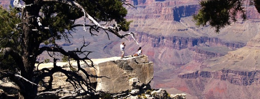
The major attraction along the South Rim is the busy village of Tusayan. The village, situated 2 miles (3.2 km) south of the Grand Canyon National Park boundary, provides several facilities like an airport, hotels, shops, an IMAX cinema, and a large RV site. There are as many as 19 viewpoints along the South Rim. These overlooks offer spectacular vistas of the Grand Canyon and the surrounding landscape. The major trails in this area include the Hermit Road and the Desert View Drive. The famous viewpoints are Hopi Point, Maricopa Point, Desert View, Grandview Point, Yavapai Point, Trail view Overlook, etc.

There are a number of panoramic but largely concealed and unreachable places along the South Rim. These include several spectacular waterfalls, narrow ravines, deep pools, and oases. Most of the magnificent side-canyons, with their allied photogenic features, require complicated journeys involving boat trips down the Colorado or more than a day traveling on foot from the Canyon’s South Rim to reach them.
Besides, there are a number of historical buildings situated along the South Rim. Most of these are located in the famous Grand Canyon Village. Major tourist attractions include the Buckey O’Neill Cabin, Kolb Studio, El Tovar Hotel, Hopi House, Verkamp’s Curious, Lookout Studio, Grand Canyon Railway Depot, Desert View Watchtower, and the famous Bright Angel Lodge.
Desert View
Desert View is a spectacular viewpoint located just four miles (6 km) from the boundary of the Grand Canyon National Park. Since the ground slopes down steeply towards the Cedar Canyon, the park road fails to follow the rim any further east. Therefore, most of the other viewpoints are all situated to the west. Desert View is, thus, the only viewpoint that offers the first sight of the magnificent Grand Canyon for visitors arriving from the east.
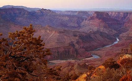
Desert View presents a very different panorama when compared to all the other overlooks in the Grand Canyon. This is because one-third of the spectacle is of the flat plains of the Painted Desert, located on the east side of Colorado. This viewpoint offers views that encompass several miles of the Grand Canyon, tributary ravines, and countless peaks. The panorama extends from the Shoshone Point in the west to the Temple and Chuar Buttes in the north. It also stretches above and beyond to the distant Echo and Vermillion Cliffs. Besides, many miles of the river, around the Tanner Creek rapids, can be viewed from here. The Tanner Creek can be accessed via the Tanner Trail that starts from the Lipan point.
The facilities provided at Desert View include a bookstore, gas station, shop, ranger station, campground, a restaurant, several acres of the parking area, and the historic watchtower, built in 1932. The famous watchtower is situated on the cliff edge and is visible for several miles across this part of the Grand Canyon. The only scenic trail at Desert View is a long Backcountry route that crosses the Painted Desert and after 16 miles from here, reaches Cape Solitude located right above the Little Colorado River Confluence.
Besides hiking, photography is also a favorite tourist activity here. The best time for photography is in the early morning when the sun first sheds light on the magnificent cliffs on the north rim below Cape Royal. Navajo point is located to the west of Desert view and Comanche Point to its east.
Desert View Drive
The Desert View Drive (AZ-64) is also popularly known as the East Rim Drive. This scenic road passes through the thick pine forest and offers only intermittent glimpses of the magnificent Grand Canyon. There are 2 major stopping places along the Desert View Drive. These are the Yaki Point after 1 mile (1.6 km) and the Grandview Point after 12 miles (19.3 km).

The Yaki Point is located near the South Kaibab trailhead. It is perhaps the best place in Grand Canyon to watch the sunset. In order to avoid overcrowding, access to the Yaki Point by private vehicles is prohibited. One can reach the Point either on foot or by a shuttle bus.
Desert View, the best in the entire Nation Park, is the final viewpoint along the drive. From here, one can view the huge, picturesque area of the Grand Canyon stretching out from a high peninsula situated just before the east entrance station. The main ravine to the north and west; the Little Colorado Gorge in the east; and the colorful Painted Desert in the northeast can also be viewed from here. In fact, it is the only overlook from which one can have a glimpse of Colorado and appreciate the striking contrast between the greenery alongside the river and the stark reddish rocks surrounding it.
The major buildings along the Desert View Drive are the Watchtower at Desert View and the Tusayan Ruins and Museum to the south. The former is a 20 m (65.6 ft) high stone tower that was constructed in 1932. The Tusayan Ruins and Museum, on the other hand, features the remains of a 12th century Anasazi settlement that was characterized by circular kivas and square houses.
Grandview Point
The Grandview Point is the southernmost point on Grand Canyon’s south rim. It can be accessed by a one-mile (1.6-km) side trail, looking out over a wide bend in the Colorado mid-way between the Grand Canyon Village and the Desert View. Since this point is the furthest from the river, it has the largest area of superseding ravines and buttes. Colorado is at a distance of 4 miles (6 km) from here.

Owing to the fact that the cliffs at the rim are less steep in this area, the Grandview trail to descend into the canyon is relatively easy. This trails drop down along the side of a narrow ridge and extend further towards Horseshoe mesa. The latter is a unique U-shaped structure situated between the Hance Creek in the east and the Cottonwood Creek in the west. Horseshoe Mesa was the site of a famous copper mine in the past.
The Grapevine Creek located in the west joins the river at a lengthy set of rapids. However, it cannot be viewed from the Grandview Point as this overlook is slightly obstructed by trees. The only glimpse of Colorado offered by the Grandview Point is of the portion that lies far to the northeast, at the mouth of Tanner Canyon. The best views offered at the point are found merely a short distance down the Grandview Trail.
Grandview Point is located at an elevation of 7,400 feet (2,300 m). It receives more rainfall as compared to other areas and has taller and denser woodland. The forest at the Viewpoint consists of a combination of oak, ponderosa pine, and pinyon pine. Grandview Point was the first place along the south rim of Grand Canyon to be established for tourists with amenities including a hotel built in 1895. However, only a little trace of it remains today. Shoshone Point is located to the west of the viewpoint while the Moran Point is to the east.
Hermit Road
Hermit Road was previously known as the West Rim Drive. It is a scenic trail that offers spectacular views of waterfalls, forests, rivers, mountains, etc. and driving through it is a trip in itself. The Hermit Road runs several miles further but as it becomes narrow and has only limited parking, entry is closed to private vehicles during the peak season. However, free shuttle buses are made available to visitors. The shuttle is rather slow and bumpy and takes 70 minutes, excluding stops, for the entire round trip.

There are as many as 6 viewpoints along the road that offers breathtaking views of the Grand Canyon and the surrounding picturesque landscape. The major Viewpoints that can be visited are the Pima Point and the Hopi Point. All these viewpoints are linked by a rim trail. This makes it easy to walk between the preferred points before resuming the shuttle.
The Hermit road is very famous among the hikers. It ends at Hermits Rest, which is the most westerly viewpoint along this trail. Trailview overlook and the Maricopa Point are the first two stopping areas along the Hermit’s Rest Route. At Hermits Rest, several other trails descend into the canyon. The Bright Angel Trail is the most popular hiking path into the Canyon. All other South Rim routes are arduous and much less-frequented.
However, if you are more adventurous and like to take up challenges, you can opt for the rather rough track that starts at the Grand Canyon Village, leads south into the forest that soon turns west, passes various other remote viewpoints and trailheads, and eventually enters the backcountry of the Havasupai Indian Reservation.
Hermits Rest
Hermits Rest is a magnificently designed rustic building situated at the end of the Hermit Road, popularly known as the West Rim Drive. It was created in the year 1914 by a renowned architect, Mary Jane Colter. The building has been designated as a National Historic Landmark. This impressive limestone building is located at an elevation of 6,650 ft (2026.9 m) above the sea level. It was named after the “hermit” Louis Boucher, a French-Canadian prospector who had several mining claims and stayed in this area all alone for more than 20 years.

The Hermit Road winds westwards from the edge of the Grand Canyon Village and runs 8 miles (12.8 km) along the rim before it ends at Hermits Rest. Hermits Rest can be accesses by bikers, hikers, shuttles as well as by private vehicles all the year-round. The multipurpose shuttle enables you to hop on and off to view and admire the Canyon perspectives and to walk sections of the Rim Trail.
Hermits Rest is the westernmost viewpoint and offers breathtaking views of the Grand Canyon. Spectacular views from here include the Hermit Rapids and the towering cliffs of the Red Wall and Supai formations. The scenic Hermit Trail, which descends from here, is a great place for hiking.
At Hermits Rest, visitors are provided with several facilities like a snack bar, an elegant gift shop, restrooms, and drinking water. The Hermits Trailhead is situated just next to the building. The major attraction in the building is the fireplace that has been made using stones covered with soot. The stone building at Hermits Rest sells refreshments and curios and is the only place having restrooms on Hermit Road.
Location: West Rim Drive/Hermit Road, Grand Canyon, AZ 86023
Hopi Point
Hopi Point is the fourth stop along the west rim shuttle bus tour or the red route. It is the northernmost area on this part of the south rim. Hopi Point, in fact, is the first Viewpoint that offers breathtaking views of the western Grand Canyon, a considerable portion of which now comes into full perspective. Hopi Point is the best place from where one can view the Great Scenic Divide and the spectacular Havasupai Point.

The viewing area at the Hopi Point is located next to the road and has been fenced. Besides, there is a panorama over the canyon centered on Dana Butte. Dana Butte is located 2,000 feet (609.6 m) below the overlook. Salt Creek that meets Colorado at a series of rapids is located on one side of the viewpoint while the Monument Creek that joins the Granite Rapids is on the other side.
A large group of prominent mesas on either side of Trinity Creek on the North Rim are located just opposite to the Hopi Point. These mesas were named after figures from ancient Egypt by geologist and writer Clarence Dutton in the 1880s. The largest among these include the Horus Temple, Osiris Temple, and the Isis Temple.
Hopi has become the most popular Viewpoint on the west rim owing to the wide-ranging, unobstructed views that it offers. It is the best place to watch the sunset at Grand Canyon. Mohave Point is located to the west of Hopi Point whereas the Powell Point lies to its east.
Maricopa Point
Maricopa Point is the first viewpoint on the Hermit’s Rest Route – a West Rim shuttle bus tour. However, it is the second stop along the route, the first being the famous Trailview Overlook. Quite a narrow promontory, extending 100 feet (30 m) northeast before descending vertically, is formed by the canyon’s edge at the Maricopa Point. This headland continues lower down as a thin ridge between the large Garden Creek and the Horn Creek.

The views from Maricopa Point include more than 180° of the Grand Canyon. There are no major obstacles between this Point and the river. Besides, several miles of the scenic Tonto Trail is also visible from here. This trail wanders around Dana Butte and the Horn Creek. This Viewpoint also offers breathtaking views of some parts of the Bright Angel Trail that meanders down the Garden Creek.
The ruins of the Orphan Mine are located to the west of the Maricopa Point. This mine was established in 1892 and served as a major source of silver, copper, silver, vanadium, and uranium from 1956 to 1969. Owing to the danger posed by the radioactive residues at this site, a significant portion of the rim trail past the vestiges is closed and diverted around the perimeter fence. This has added half a mile to the short trail to the west of the viewpoint. This short walk leads to the next major viewpoint called the “Powell Point”. The famous Grandeur Point lies to the east of the Maricopa Point.
The other attractions at the Viewpoint include the winch engine and several abandoned buildings. There are several tunnels and actual shafts about 1,000 feet (304.8 m) lower down in a mineralized portion of the Coconino sandstone layer.
Trailview Overlook
The Trailview Overlook is a spectacular viewpoint located along the south rim of Grand Canyon. It is known for the breathtaking views that it offers. This viewpoint provides a spectacular view of the scenic Plateau Point trail dropping down the canyon. It also offers dramatic views of the Bright Angel Trail. The Trailview Overlook is, in fact, the best place to watch the mule trains and the hikers descending and ascending this trail.

This viewpoint literally reaches out into the Canyon and offers several other beautiful sights. One can view the deep gorge to the north where the spectacular Bright Angel Creek, a permanent tributary stream of the Colorado River, flows. Trailview Overlooks also provides an unobstructed view of the distant San Francisco Peaks situated towards the south. Panoramic views of Arizona’s highest mountains, Bill Williams Mountain, and Red Butte also attract tourists to this viewpoint.
Besides, one can also get a view of the famous Lookout studio and the Kolb studio from here. Shuttle bus services are made available at the viewpoint. The next viewpoint that you can go to from here is the Powell Point that also offers great views of the Canyon.
Yavapai Point
Yavapai Point is a spectacular viewpoint situated along the south rim. It is a short walk west of the famous Mather Point. At Yavapai Point, there is a Visitor Center, known as the Yavapai Observation Station, which sells several books and displays interesting information about the history and geology of the magnificent Grand Canyon.

Yavapai Point offers exceptional views but only limited parking. Vehicles over 22 feet (6.7 m) are not allowed in the area. It is, in fact, the northernmost viewpoint on this part of the south rim and provides the best panorama of the three points situated in this area. Being the closest to the Colorado River, Yavapai Point allows unobstructed views up and down the gorge.
Plateau Point to the west of the Pipe Creek can be accessed via the Bright Angel Trail and is visible from the Yavapai Point. The beautiful river at the end of the Pipe Creek is visible due north. In the other direction, a long thin ridge, running from Yaki Point and extending two-thirds of the way to the river, dominates the nearby ground. Several peaks and points all the way to Palisades of the Desert and the Desert View can be viewed from the Yavapai Point.
This viewpoint also offers the breathtaking view of the three large canyons meeting Colorado on the North Rim. In the west, one can see the Trinity Creek flow from beneath Shiva Temple and join the river near Hopi Point. The Bright Angel Canyon, long, straight drainage, is located just opposite the Yavapai Point. A few miles further east, one can view the Clear Creek form a deep canyon, which extends a long, long way northwards towards the secluded Walhalla Plateau, beneath Cape Royal. Grandeur Point is located to the west of the Yavapai Point.