Best Corsica Beaches 2024
Around one-and-three-quarter million people visit Corsica each year, drawn by a climate that’s mild even in winter and by some of the most astonishingly diverse landscapes in Europe.
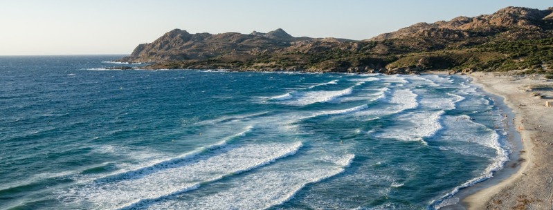
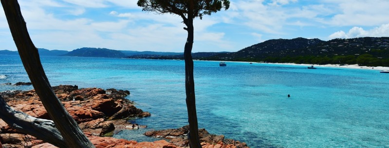
Nowhere in the Mediterranean are there beaches finer than Corsica’s perfect half-moon bays of white sand and transparent water, or seascapes more inspiring than the granite cliffs of the west coast.
Even though the annual influx of tourists now exceeds the island’s population sevenfold, tourism has not spoilt the place: there are a few resorts, but overdevelopment is rare and high-rise blocks are confined to the main towns.
Best Corsica beaches:
Ajaccio
Edward Lear claimed that on a wet day it would be hard to find so dull a place as Ajaccio (Aiacciu), a harsh judgment with an element of justice. The town has none of Bastia’s sense of purpose and can seem to lack a definitive identity of its own, but it is a relaxed and good-looking place, with an exceptionally mild climate, and a wealth of cafes, restaurants, and shops.
The core of the old town holds the most interest in Ajaccio: a cluster of ancient streets spreading north and south of place Foch, which opens out to the seafront by the port and the marina.
Nearby place de Gaulle forms the town center and is the source of the main thoroughfare, Cours Napoleon, which extends parallel to the sea almost 2km to the northeast.
West of place de Gaulle stretches the modern part of town fronted by the beach, overlooked at its northern end by the citadel.
Bastia
The dominant tone of Corsica’s most successful commercial town, Bastia, is one of charismatic dereliction, as the city’s industrial zone is spread onto the lowlands to the south, leaving the center of town with plenty of aged charm.
The old quarter, known as the Terra Vecchia, comprises a tightly packed network of haphazard streets, flamboyant Baroque churches, and lofty tenements, their crumbling golden-grey walls set against a backdrop of maquis-covered hills. Terra Nova, the historic district on the opposite side of the old port, is a tidier area that’s now Bastia’s yuppie quarter.
Crowded with schoolchildren in the summer, the pebbly town beach in Bastia is only worth visiting if you’re desperate for a swim. To reach it, go left at the flower shop on the main road south out of town, just beyond the citadel.
A better alternative is the long beach of L’Arinella at Montesoro, a further 1km along the same road, the beginning of a sandy shore that extends along the whole east coast. A bus to L’Arinella leaves from outside Cafй Riche on boulevard Paoli every twenty minutes; just get off at the last stop and cross the train line to the sea. There are a couple of sailing and windsurfing clubs here and a bar.
Bonifacio
Bonifacio (Bonifaziu) enjoys a superbly isolated situation at Corsica’s southernmost point, a narrow peninsula of dazzling white limestone creating a town site unlike any other.
The much-photographed Haute Ville, a maze of narrow streets flanked by tall Genoese tenements, rises seamlessly out of sheer cliffs that have been hollowed and striated by the wind and waves, while on the landward side the deep cleft between the peninsula and the mainland forms a perfect natural harbor.
A haven for boats for centuries, this inlet is nowadays a chic marina that attracts yachts from all around the Med. Separated from the rest of the island by a swathe of dense maquis, Bonifacio has maintained a certain temperamental detachment from the rest of Corsica and is distinctly more Italian than French in the atmosphere.
Such a place has its inevitable drawbacks: exorbitant prices, overwhelming crowds in August, and a commercial cynicism that’s atypical of Corsica as a whole. However, the old town forms one of the most arresting spectacles in the Mediterranean, easily transcending all the tourist frippery that surrounds it, and warrants at least a day trip. If you plan to come in peak season, try to get here early in the day before the bus parties arrive at around 10 am
The beaches along this part of the coast are generally smaller and less appealing than most in southern Corsica, although those fringing the Golfe de Santa Manza, to the north, are set amid some fine scenery. On the southernmost tip of the island, reached via a narrow but easily motorable road, a trio of small coves is the most popular beach within easy reach of the town. The first, plage de Pianterella, 7km east of Bonifacio, is also the dullest, backed by an unsavory swamp. Walk south around the headland for fifteen minutes and you’ll reach the more pleasant plage de Sperone, a pearl-white cove with calm, shallow water that’s ideal for kids. However, this beach gets jam-packed in the summer and you may want to venture further along the coast to Calalonga, where you stand a better chance of escaping the crowds. To get there, head east of town on the D58, and take the first turning right, after around 3km.
By far the most photogenic beach in this area is Rondinara, a perfect shell-shaped cove of turquoise water enclosed by dunes and a pair of twin headlands. Thankfully, it is well off the beaten track, although the recent appearance of a surfaced road all the way to the beach could well change that. To see it at its most empty, get here early in the morning. The turning for Rondinara is signposted 10km north along N198.
Cap Corse
Until Napoleon III had a coach road built around Cap Corse in the nineteenth century, the promontory was effectively cut off from the rest of the island, relying on Italian maritime traffic for its income – hence its distinctive Tuscan dialect. Many Capicursini later left to seek their fortunes in the colonies of the Caribbean, which explains the distinctly ostentatious mansions, or palazzus, built by the successful emigrйs (nicknamed “Les Americains”) on their return. Despite all the changes brought by the modern world, Cap Corse still feels like a separate country, with wildflowers in profusion, vineyards, and quiet, traditional fishing villages.
Forty kilometers long and only fifteen across, the peninsula is divided by a spine of mountains called the Serra, which peaks at Monte Stello, 1037m above sea level. The coast on the east side of this divide is characterized by tiny ports, or marines, tucked into gently sloping river mouths, alongside coves that become sandier as you go further north. The villages of the western coast are sited on rugged cliffs, high above the rough sea, and tiny rocky inlets that can be glimpsed from the corniche road.
A port since Roman times, well-sheltered Macinaggio, 20km north of Erbalunga, was developed by the Genoese in 1620 for the export of olive oil and wine to the Italian peninsula. The Corsican independence leader, Pascal Paoli, landed here in 1790 after his exile in England, whereupon he kissed the ground and uttered the words ” O ma Patrie, Je t’ai quittй esclave, Je te retrouve libre ” (“Oh my country, I left you as a slave, I rediscover you a free man”) – a plaque commemorating the event adorns the wall above the ship chandlers. There’s not much of a historic patina to the place nowadays, but with its boat-jammed marina and its line of colorful seafront awnings, Macinaggio has a certain appeal, made all the stronger by its proximity to some of the best beaches on Corsica. North of the town lies some stunning stretches of white sand and clear sea. A marked footpath, known as Le Sentier des Douaniers because it used to be patrolled by customs officials, threads its way across the hills and caves along the coast, giving access to an area that cannot be reached by road. The Baie de Tamarone, 2km along this path, has deep clear waters, making it a good place for diving and snorkeling.
Set high on a black rocky pinnacle that plunges vertically into the sea, the village of Nonza, 18km south of Centuri, is one of the highlights of the Cap Corse shoreline. It was formerly the main stronghold of the da Gentile family, and the remains of their fortress are still standing on the furthest rocks on the overhanging cliff.
Nonza is also famous for St Julia, patron saint of Corsica, who was martyred here in the fifth century. The story goes that she had been sold into slavery at Carthage and was being taken by ship to Gaul when the slavers docked here. A pagan festival was in progress, and when Julia refused to participate she was crucified; the gruesome legend relates that her breasts were then cut off and thrown onto a stone, from which sprang two springs, now enshrined in a chapel by the beach.
To get there, follow the sign on the right-hand side of the road before you enter the square, which points to La Fontaine de Ste-Julia, down by the rocks. Reached by a flight of six hundred steps, Nonza’s long grey beach is discolored as a result of pollution from the now disused asbestos mine up the coast. This may not inspire confidence, but the locals insist it’s safe (they take their own kids there in summer), and from the bottom, you do get the best view of the tower, which looks as if it’s about to topple into the sea.
Cargese
Sitting high above a deep blue bay on a cliff scattered with olive trees, Cargese (Carghjese), 20km southwest of Porto, exudes a lazy charm that attracts hundreds of well-heeled summer residents to its pretty white houses and hotels.
The full-time locals, half of whom are descendants of Greek refugees who fled the Turkish occupation of the Peloponnese in the seventeenth century, seem to accept with nonchalance this inundation, and the proximity of a large Club Med complex, but the best times to visit are May and late September when Cargese all but empties.
The best beach in the area, plage de Pero, is 2km north of the village – head up to the junction with the Piana road and take the left fork down to the sea. Overlooked by a Genoese tower, this white stretch of sand has a couple of bars and easily absorbs the crowds that descend on it in August.
Plage du Chiuni, a further 2km along the same road, is much busier thanks to its windsurfing facilities and the presence of Club Med.
A more secluded spot is plage du Monachi, 1km south of the village; this small, sandy cove is reached by climbing down the track at the side of the road past the little chapel on the cliffside.
Golfe de Porto-Vecchio
Much of the coast of the Golfe de Porto-Vecchio and its environs is characterized by ugly development and hectares of swampland, yet some of the clearest, bluest sea, and whitest beaches on Corsica are also found around here. The most frequented of these, Palombaggia and Santa Giulia, can be reached by bus from the town in summer, timetables for which are posted in the tourist office; at other times you’ll need your own transport, or be prepared to hitch. The same applies to the Casteddu d’Araggiu, one of the island’s best-preserved Bronze Age sites, which stands on a ledge overlooking the gulf to the north of town.
Heading south of Porto-Vecchio along the main N198, take the turning signposted for Palombaggia, a golden semicircle of sand edged by short twisted umbrella pines that are punctuated by fantastically shaped red rocks. This might be the most beautiful beach on the island were it not for the crowds, which pour onto it in such numbers that a wattle fence has had to be erected to protect the dunes.
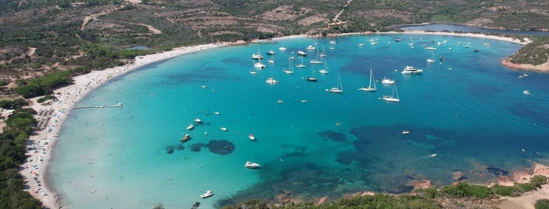
A few kilometers further along the same road takes you to Santa Giulia, a sweeping sandy bay backed by a lagoon. Despite the presence of several holiday villages and facilities for windsurfing and other noisier watersports, crowds are less of a problem here, and the shallow bay is an extraordinary turquoise color.
North of Porto-Vecchio, the first beach worth a visit is San Cipriani, a half-moon bay of white sand, reached by turning left off the main road at the Elf garage. Carry on for another 7km, and you’ll come to the even more picturesque beach at Pinarellu, an uncrowded, long sweep of soft white sand with a Genoese watchtower and, like the less inspiring beaches immediately north of here, benefiting from the spectacular backdrop of the Massif de l’Ospedale.
Campomoro
Isolated at the mouth of the Golfe de Valinco, Campomoro, 17km southwest of Propriano, ranks among the most congenial seaside villages on the island.
The main attraction here is a two-kilometer-long beach, overlooked by an immense and well-preserved Genoese watchtower. In late July and August, it’s swamped by Italian families from the adjacent campsites, but for the rest of the year, Campomorro remains a tranquil enough place, with barely enough permanent residents to support a post office.
Another incentive to venture out here is the wild and windswept stretch of the coast south of Campomorro, which is punctuated by outlandish rock formations and a string of empty pebble beaches. The absence of a road into the area, recently designated a regional nature reserve, means the only way to explore it is by boat or on foot, via the waymarked coastal path that begins below Campomorro’s watchtower.
Propriano
Tucked into the narrowest part of the Golfe de Valinco, the small port of Propriano (Prupria), 8km northwest of Sartene, centers on a fine natural harbor that was exploited by the ancient Greeks, Carthaginians, and Romans, but became a prime target for Saracen pirate raids in the eighteenth century when it was largely destroyed. Redeveloped in the 1900s, it now boasts a thriving marina, and handles ferries to Toulon, Marseille, and Sardinia.
The occasional eruption of violence, however, doesn’t deter the tourists, who come here in droves for the area’s beaches. The nearest of these, plage de Lido, lies 1km west, just beyond the Port de Commerce; it’s patrolled by lifeguards during the summer and is much safer and more appealing than the grubby plage de Baracci, 1km north of town, where the undertow is precariously strong.
Just 3km beyond the Baracci beach, the D157 branches off to the left and continues along the coast, which is built up with hotels and package-tour holiday blocks until Olmeto plage, 10km west, where an abundance of campsites are on offer. You can reach Olmeto on the three daily buses from Propriano to Porto.
Desert des Agriates
Extending westwards from the Golfe de St-Florent to the mouth of the Ostriconi River, the Desert des Agriates is a vast area of uninhabited land, dotted with clumps of cacti and scrub-covered hills. It may appear inhospitable now, but during the time of the Genoese, this rocky moonscape was, as its name implies, a veritable bread basket (agriates means “cultivated fields”).
In fact, so much wheat was grown here that the Italian overlords levied a special tax on grain to prevent any build-up of funds that might have financed an insurrection. Fires and soil erosion eventually took their toll, however, and by the 1970s the area had become a total wilderness.
A couple of rough pistes wind into the desert, but without some kind of 4WD vehicle the only feasible way to explore the area and its rugged coastline, which includes two of the island’s most beautiful beaches, is by foot. From St-Florent, a recently inaugurated pathway winds northwest to plage de Perajola, just off the main Calvi highway (N1197), in three easy stages.
The first takes around 5hr 30min and leads past the famous Martello tower and much-photographed plage de Loto to plage de Saleccia, a huge sweep of soft white sand and turquoise sea that was used as a location for the invasion sequences in the film The Longest Day. There’s a seasonal campsite here, U Paradisu (closed Nov-April).
From plage de Saleccia, it takes around three hours to reach the second night halt, plage de Ghignu, where a simple gite d’etape provides basic facilities. The last stretch to Perajola can be covered in under six hours.
Porto
The overwhelming proximity of the mountains, combined with the pervasive eucalyptus and spicy scent of the maquis, give Porto, 30km south of Calvi, a uniquely intense, loaded atmosphere that makes it one of the most interesting places to stay on the west coast.
Except for a watchtower built here by the Genoese in the second half of the sixteenth century, the site was only built upon with the onset of tourism in the 1950s; today the village is still so small that it can become claustrophobic in July, and August when overcrowding – thanks to predominantly German tourists – is no joke. Off-season, the place becomes eerily deserted, so you’d do well to choose your times carefully; the best months are May, June, and September.
Eucalyptus-bordered route de la Marine links the two parts of the resort. The village proper, known as Vanita, comprises a strip of supermarkets, shops, and hotels 1km from the sea, but the main focus of activity is the small marina, located at the avenue’s end. Overlooking the entrance to the harbor is the much-photographed Genoese Tower, a square chimney-shaped structure that was cracked by an explosion in the seventeenth century when it was used as an arsenal. An awe-inspiring view of the crashing sea and maquis-shrouded mountains makes it worth the short climb.
The beach consists of a pebbly cove south beyond the shoulder of the massive rock supporting the tower. To reach it from the marina, follow the little road that skirts the rock, cross the wooden bridge which spans the River Porto on your left, then walk through the car park under the trees. Although it’s rather rocky and exposed, and the sea very deep, the great crags overshadowing the shore give the place a vivid edge.
Porto-Vecchio
Set on a hillock overlooking a beautiful deep blue bay, Porto-Vecchio, 25km north of Bonifacio, was rated by James Boswell as one of “the most distinguished harbors in Europe”. It was founded in 1539 as a second Genoese stronghold on the east coast, Bastia being well established in the north.
The site was perfect: close to the unexploited and fertile plain, it benefited from secure high land and a sheltered harbor, although the mosquito population spread malaria and wiped out the first Ligurian settlers within months. Things began to take off mainly thanks to the cork industry, which still thrived well into the twentieth century.
Today a third of Corsica’s wine is exported from Porto-Vecchio, but most revenue comes from tourists, the vast majority of them well-heeled Italians who flock here for the fine outlying beaches: spectacular stretches of shoreline lie to the south, with Palombaggia the most popular and Golfe de Santa Giulia coming a close second, while to the north, the deep inlet of the Golfe de Porto-Vecchio boasts some fine pine-backed strands.
To the northwest, the little town of Zonza makes a good base for exploring the dramatic forestry that surrounds the route de Bavella.