
Best Urban Phoenix Hikes
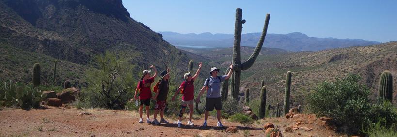
Two favorite Phoenix hikes that people absolutely rave about are the Piestewa Peak Summit Trail and the North Mountain Park. The fresh smell in the morning air along with the stillness that prevails makes for the appreciation of who we are on this planet. On the other end of the day when the desert winds down, spectacular, brilliantly colored sunsets paint the mountains as if they were an artist’s palette. With the changes in light, views seem totally different than they are during the daytime. Capture the moments with photos that will be appreciated by you and your friends and colleagues for years to come.
Piestewa Peak Summit Trail
Want a quick hike that will satisfy the outdoor crave? Located in the heart of Phoenix, The Summit Trail at Piestewa Peak is a relatively easy hike for well-conditioned hikers and offers spectacular views of the thriving metropolis below. It’s always waiting when the hiking urge strikes. Piestewa Peak was originally known as Squaw Peak and was renamed in 2004 in honor of Lori Piestewa, a Hopi Indian woman who was the first Native American woman to die in an American war. She was killed in the Iraq Conflict.
Piestewa Peak (Squaw Peak) at Dreamy Draw Park
The Dreamy Draw Area Park and Preserve lies beneath the shadow of Piestewa Peak’s 2,600-foot summit. Of the seven self-guided hiking trails in the park, three are rated moderate to difficult climbs. The remaining four are easy to moderate hikes. With the exception of Summit Trail, all hiking trails permit biking and horseback riding.
Summit Trail is the most popular with an elevation gain of over 1,200 feet. Those that reach the summit of Piestewa Peak are rewarding with fantastic views. Dogs on leash are permitted on all trails. Parking, picnic areas, and restrooms are available.
Hiking Piestewa
Climbing Piestewa Peak at night offers incredible views of the night lit Phoenix skyline, but it’s wise to try the hike during daylight hours before making a nighttime climb. Don’t forget your flashlight. There are places one could get real lost if there are no other hikers to follow.

Piestewa attracts 4,000 to 10,000 hikers weekly that challenge the 1.2-mile trail as it gains over 1200 feet in elevation. Although not particularly difficult, the quick gain in elevation requires good physical condition. Depending upon the skill of the hiker and how often he or she stops to enjoy the views, the hike typically takes about 30 minutes to 1 and 1/2 hours. The trail conveniently locates stone bench rest stops where weary hikers can catch their breath or take memorable photos.
Much of the terrain on Summit Trail can be loose and slippery, so be sure to wear a good pair of hiking shoes or boots with good traction and ankle support. Also, wear athletic and comfortable clothing fitting the weather. Remember, the climate in Phoenix can reach high temperatures during the summer months. Be careful of the cacti. Their sharp, spiney needles can do damage.
Absolutely bring bottled water to replenish lost fluids and it’s wise to take granola bars or small-sized snacks to replace body fuel. Be courteous to other hikers and always allow faster hikers to pass, particularly along with narrow areas on the trail. Taking a cell phone is a good idea in case you encounter problems.
Hikers to the summit of Piestewa Peak will be rewarded with amazing views across the Phoenix horizon.
Trail 300 – Summit Trail
Trail Length: 1.2 miles
Elevation Gain: 1,200 feet
Elevation: 1,400 to 2,608 feet
Difficulty: Moderate to difficult
Getting To Piestewa Peak
Turn east on Squaw Peak Drive from Lincoln Drive between 22nd and 24th streets in Phoenix. The Summit Trailhead is located in the parking lot at the first driveway on the left in Phoenix Mountains Park and Recreation Area. Drinking water and restrooms are available. Note that dogs and bicycles are not permitted on the Summit Trail at Piestewa.
Climb to the Peak or the Loop
This is our shortest, moderate, or challenging program for a quick workout. This adventure is ideal for folks with a limited amount of time coupled with that urge to “get up and go!” It’s a fast and really fun 2-hour energizing experience. There’s continuous elevation gain along wonderfully scenic Sonoran Desert mountain trails. When we finally reach the summit on this challenging trail, you’ll be proud that you’ve achieved your goal. You got up and went! You’ll be in awe of the majestic panoramic view presented right before your eyes! A more modest trail on the same mountain affords equally magnificent valley views with less of a challenge. You Decide! We Provide! Late afternoon/evening hikes offer the chance to see that perfect sunset too. These hikes are a must-do and highly recommended.
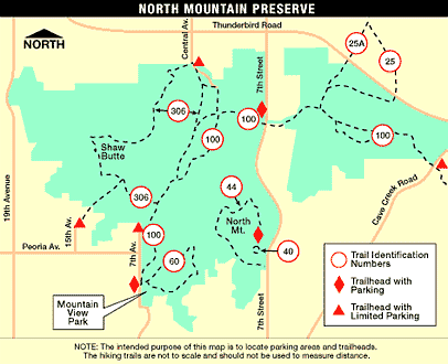
North Mountain Park – Hiking Trails & Picnic Ramadas
North Mountain Park features 5 self-guided hiking trails including the Penny Howe, Shaw Butte, Maxin Lakin, North Mountain, and Charles M. Christiansen Memorial. These five hiking trails range in level of difficulty from easy to difficult, traversing over 20 miles of desert terrain. All trails are multi-use including hiking, biking and horseback riding.
North Mountain and Shaw Butte reach heights of just over 2,100 feet with spectacular panoramic views of the Phoenix area. Paved parking, picnic areas and restrooms are available. Parking lot hours are 5:00 AM to 7 PM or sunrise or sunset, whichever comes first.
Located in north Phoenix, North Mountain once served as a campground for the students at Phoenix Indian School which is no longer a school. At 2,194 feet, North Mountain is a landmark peak with great panoramic views of the city from its summit. Large ramadas are available for picnic reservations and other smaller ones are available first-come, first-serve.
 Visit the Visitors Center for seasonal schedules and open times. The Center will give you insights into the richness and diversity of hiking in the Sonoran Desert. Educational classes and events are continuously scheduled. The Center sponsors a Wednesday Walking Club.
12950 North 7th Street
Phoenix, Arizona
Near Thunderbird Road and 7th Street
(620) 495-5540
Hiking Trails At North Mountain
The Mountain Preserve features a variety of trails for all skill levels. The trails are multipurpose unless otherwise marked. See the map below for trail locations and the best places to park to reach each trail.
Trail 40
Penny Howe Barrier-Free Nature Trail
Trail Length: 0.3 Mile
Elevation: 1,420 to 1,380 feet
Difficulty: Easy
Trail 306
Shaw Butte Trail
Trail Length: 4 Miles
Elevation: 2,044 to 1,390 feet
Difficulty: Moderate to difficult
Trail 60
Maxine Lakin Nature Trail
Trail Length: 1.2 Miles
Elevation: 1,408 to 1,290 feet
Difficulty: Easy to moderate
Trail 44
North Mountain National Trail
Trail Length: 1.6 Miles
Elevation: 2,104 to 1,490 feet
Recommended for hiking only
Difficulty: Moderate to difficult
Trail 100
Charles Christiansen Memorial Trail
Trail Length: 10.7 Miles
Elevation: 2,080 t0 1,290 feet
Difficulty: Easy to moderate
North Mountain Hiking Trail Map
More Information. Click here for more detailed information about North Mountain and Shaw Butte including hiking trail descriptions, photos, directions, and maps.
Ranger Office: 602-262-7901
10600 North 7th Street (between Peoria and Thunderbird Roads)
Papago Park Hiking
Papago Park is located on the east side of Phoenix, near the border of Tempe and South Scottsdale. The hiking trails are easy hikes and are relatively smooth. The 1,200-acre park is home to “Hole in the Rock” a red rock that is distinctive to its landscape. Hiking up the backside of the hill leads to the hole where views are incredible.
There are several picnic ramadas surrounding a 7.8-acre lagoon that is regularly stocked with fish. Be sure to get a required urban fishing license. Papago Park is also home to the Phoenix Zoo and the Desert Botanical Garden. The Park’s desert hiking trails meander more than 5 miles across the park with little elevation gain. It’s perfect for the entire family to go hiking and spend the day relaxing.
More Information. See the City of Phoenix Papago Park Information of guidelines, Ramada use, and maps. Call (602) 261-8318 for general information. Located at Van Buren Street and Galvin Parkway.
Reach 11 Recreation Area
Reach 11 is a 1,500-acre horse lover’s park but has a Barrier-Free Access Nature Trail that is strictly for hiking that prohibits horses and bikes. This is a perfect equestrian park that includes a 90-acre equestrian facility with four lighted arenas and 18 miles of wide, multi-use trails. The park terrain is relatively flat with minor grade changes at wash crossings. Trails are open from sunrise to sunset.
More Information
Click here for more information about Reach 11 Recreation Area including hiking trail descriptions, photos, directions, and maps.
General Information
(602) 534-6265 North of the Central Arizona Project Canal between Cave Creek and Scottsdale Road. Primary access points to the park are provided at Tatum Boulevard, Cave Creek Road, 56th Street and Scottsdale Road.