Biking Coronado National Forest
The Coronado National Forest spans 1,780,000 acres of SE Arizona and SW New Mexico. Elevations in twelve widely scattered mountain ranges or “sky islands” range from 3000 to 10,720 feet that rise energetically from the desert floor, creating plant communities as biologically diverse as those you would encounter on a trip all the way from Mexico to Canada.
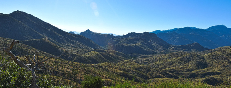
Views are spectacular from these mountains. Experience all four seasons in a single day’s journey, spend the morning wandering among giant saguaros and beautiful wildflowers, have a picnic lunch under the gorgeous golden leaves of a cottonwood tree, and play in the snow later in the afternoon.
The Coronado National Forest offers many recreational opportunities throughout the year. The higher elevations are most popular during the summer, offering temperatures 20 or more degrees cooler than the desert on any day of the year. These mountaintop sites also provide opportunities to ski and play in the snow during the winter months. Many of the low elevation recreation areas are located in scenic canyons or foothills, and these sites are most popular during the fall, winter, and spring. Over 1,100 miles of trails are available. Interpretive trails in and around prehistoric and historical sites allow you to experience the forest’s heritage. Four small lakes provide water-based activities. Eight wilderness areas encompassing 338,536 acres offer visitors solitude and primitive recreation.
Chiva Falls Quick Facts
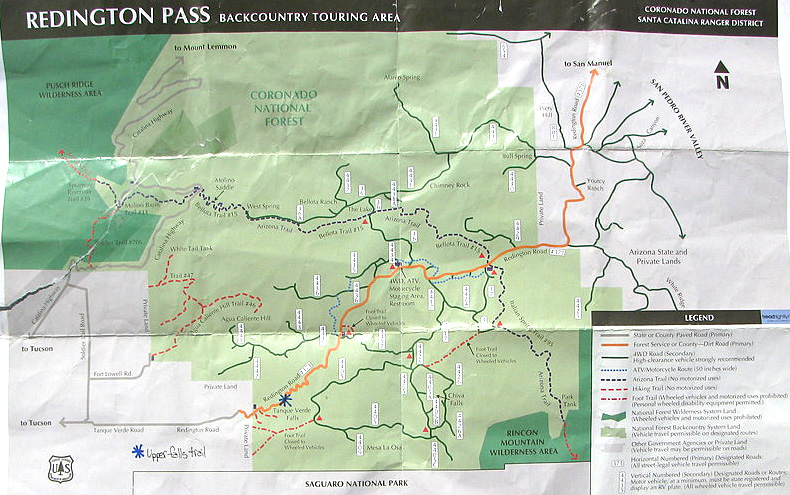
- Location: Tucson, Arizona
- Directions to Park: Take Tanque Verde Road east to Redington Road (where the pavement stops). The main trailhead is approximately 4.7 miles pretty much straight up a rocky incline from where the pavement stops. The parking area is on the right across from a corral.
- Activities: Mountain biking, hiking, camping, ORV, 4×4
- Admission: currently none
- Contact: Coronado National Forest, 300 W. Congress St., Tucson, AZ 85701
- Phone: (520) 670-4552 TTY: (520)670-4584
- Trail(s): Many miles of wide and rocky double track. This ride was a loop. Trail 4426 to 4417 to Redington Road and back to the parking area.
- Difficulty: Strenuous Intermediate/Advanced with technical descents.
Chiva Falls Mountain Biking Trails
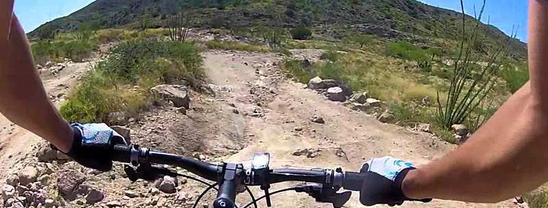
Chiva Falls area is one of the more talked about rides in the Tucson area. Chiva Falls’ main trailhead is accessible via Tanque Verde Road to where the pavement stops at Redington road. From there, you’ll travel 4.7 miles, mostly straight up a horrendously rocky road. You’ll need a high clearance vehicle for this part. 4.7 miles from where the pavement stops and Redington begin, you’ll spot a fenced-in area to your right. When I arrived, the lot was empty, and I didn’t know if it was the correct trailhead. I had heard that it was generally busy.
At any rate, I jumped out, readied my bike and hydration pack, popped my helmet on and rode off into the great unknown. I wasn’t even exactly sure if I was on the right trail. All I knew was I had a map, and I was on some path. I could work the rest out later. The path I was on turned out to be pretty typical of the trails in Chiva Falls in that they are full, rocky Jeep roads. Mountain biking in this area seems to be tagging along on the bumpers of off-road 4x4s. I almost immediately was greeted with a very rocky teeth-rattling downhill and a calf busting rocky and long ascent. For the most part, this is the character of Chiva Falls. When I paused to look up, I was surrounded by beautiful high desert and mountain scenery. It was around the beginning when I spotted the only people I would see for almost the entire ride. A couple in a big tired 4×4 plundered up the trail I was descending. They smiled and waved as I gave them plenty of room.
Many tough climbs and descents later, around what felt like 40 minutes into my adventure, I came to a well-marked junction! Finally, I could get a bearing on my map. I was at a crossroads of trails 4426, which I was on and 4117. It was on my map… Even better news; I was also where I thought I was. If I had planned a little better, I would have known that riding A short distance from where I was would have taken me to the waterfall that the area is named for. I continued back towards Redington Road in 4417. I could have kept riding to the Chiva Falls area by staying on 4426 to where 4405 joins on the left. It would have added maybe 45 minutes total to my ride and my kind of wish I would have known this, although, I was happy to know where I was. I headed back towards Redington Road.
The trail remained about the same as it was previously, which is to say by now was tiring me a little. I managed to do a few climbs that I didn’t think I could have as well as bailing out on a more than a couple of climbs that looked just plain impossible for all but Ned Overend to make. At one point, after a technical descent that required all of my attention, I stopped at the bottom, took a deep breath, and looked up for the first time in about a minute or two; skittish but oddly curious cows surrounded me.
One thing I did note is that there is NO shade on this trail at all. I can imagine that it’s an excruciating ride in the warmer months. Today, by comparison, was just about perfect except my burning calves! As I neared Redington Road, I passed the only other people I would see on the trail; a group of car campers that were enjoying lunch. I rode by them unnoticed. When I reached Redington Road, I hung a left (west) to head back to the main trailhead where I started.
In contrast to the Jeep roads I had just been on, Redington Road now seemed relatively smooth! I came upon a mile marker that was 11.5. I don’t fully understand the system as I had noticed a marker that said 4 or 4.5 pretty early into Redington Road. Doing the math, I knew that I would have a 7.5-mile ride to the entrance at Tanque Verde Road. Before I left the trailhead this morning, my companion mentioned that she didn’t want to drive back up the mountain, so I told her that I would meet her at the bottom.
I’ve now noticed that from the point I entered Redington Road, heading back towards the entrance, two short Jeep roads loop back to Redington after a short distance. I didn’t ride these but wish I’d checked them out. Shortly after the trail I was on (4426) enters Redington, heading west, I found some of the prettiest scenery I had seen yet. Grassy fields and trees framed in beautiful views of the mountains that had been looking down on me all day. Redington, as I mentioned, is predominately uphill as I headed in towards the trailhead in the morning. I now knew that I was going to have a bombing descent to look forward to. I soon caught two other bikers on one of the few climbs on Redington before the significant drop. My fellow biker company was short-lived as we crested the top of the climb. They took off down the mountain with incredible speed. They were a lot more daring and familiar with the road than I. I never saw them again. I think they must have been in the next county by the time I reached the entrance. After a short ride down Tanque Verde and a short wait at a gas station just outside the entrance, I spotted my wife coming to pick me up.
Chiva Falls offers a lot of choices for mountain bike riding trails. The trails here seem to be broad, rough, tough, and technical in a boulder dodging way. I would recommend them for the experienced rider who has a reasonable level of physical fitness. I believe beginners would find pushing their bikes up and down hills quite frustrating. Make sure to bring plenty of water and sunscreen, as there was no shade on the trails I rode. The Chiva Falls Loop took me approximately 1.5 hours with a couple of breaks and some photo snapping.
Chivas Falls Biking Tips
- Don’t miss the waterfall – Chiva Falls.
- The trails in this area are a lot harder than some advertise. Although the trail is wide double track, there are a lot of rocky technical descents and lung-busting long climbs.
- The scenery is incredible.
- Don’t miss a ride down Redington Road from the second trailhead heading back to the first trailhead. The scenery is great and the long descent after the first trailhead is fun