Alaska National Parks Guide
Located in the northwest tip of the USA, Alaska is unique among all the 50 states in the country as it does not have a continuous territory as Canadian land separates it from the nation’s boundary. Alaska depicts a great deal of racial diversity and is home to families from various ethnic and cultural backgrounds.
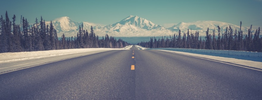
Numerous mountain ranges are found all across the state with Alaska Ranges, Saint Elias Mountains, and the Chugach Mountains being well known. Several National Parks and nearly 120 state parks are present, with the largest state park being the Wood-Tikchik State Park covering 1.55 million acres (6280 sq. km.). Alaska has a wealth of forest and ocean reserves with the Tongass National Forest being the largest in the country.
Amazing and rare wildlife like the rare Kodiak bear, the beautiful and extensive coastline for memorable cruises, the innumerable glaciers, towering mountain peaks, stunning lakes and the abundant opportunities for outdoor sport make Alaska the grand American vacation destination.
Denali National Park and Preserve, Alaska
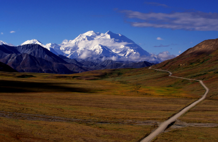
Denali National Park & Preserve is situated 240 miles north of Anchorage and is named after the Athabascan word for its most famous landmark, the 20,320-foot tall Mount McKinley. The mountain is not the park’s only attraction, however. A ride through Denali offers a look at a vast world of tundra, glaciers and abundant wildlife.
Gates of the Arctic National Park and Preserve, Alaska
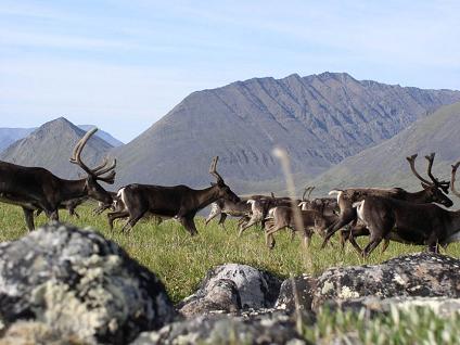
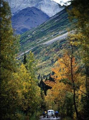
This is a very remote park in the Arctic Circle which is not accessible by road. Most visitors fly in by plane, whilst a few hike in. Careful planning is needed for any visit due to the remote location, but the effort is well worth it for a true sense of wilderness and tranquility. Camping in the park is possible with the correct preparation and it is a great way to see the birdlife which is active in the early morning as well as animals such as black and Grizzly bears, caribou, moose and wolves.
Built in the 1970s, the Dalton Highway runs almost three hundred miles north of the Arctic Circle through the increasingly barren territory. Most people are happy to return south at this point, but the highway continues to climb through the largely unexplored Brooks Range, a 9,000 ft chain mostly held within the Gates of the Arctic National Park.
Gates of the Arctic National Park and Preserve is a vast region of national parks, monuments, and preserves located north of the Arctic Circle. From the crest, at Atigun Pass you descend through two hundred miles of grand glaciated valleys and blasted arctic plains to the end of the road at a place called Deadhorse. You can’t camp or stroll here, so your choices are either staying in a hotel or taking a $25 tour of the adjacent Prudhoe Bay oil facility, worth it just for the sight of the Arctic Ocean after the long drive.
Many rivers and glaciers have sculpted large valleys in this arctic wilderness. In other valleys, the rivers have carved steep V-shaped canyons. The rugged mountains are covered with forest and arctic tundra. Moose, caribou, Dahl sheep, wolves, and grizzly bears are frequently seen here.
The park is a great refuge for the tourist who is looking for solitude, wilderness travel, and adventure. However, because Gates of the Arctic National Park and Preserve is a wilderness designated region, there are no National Park Service campgrounds, established trails or other visitor facilities within the Park boundaries.
Glacier Bay National Park and Preserve, Alaska
Glacier Bay National Park is one of the world’s most magnificent environmental preserves. It is one of the largest internationally protected Biosphere Reserves in the world and is recognized by the United Nations as a World Heritage Site. Since 1794, the Grand Pacific Glacier has receded 65 miles to reveal a tranquil world of deep fjords lined by rock walls and fed by fifteen other receding tidewater glaciers.
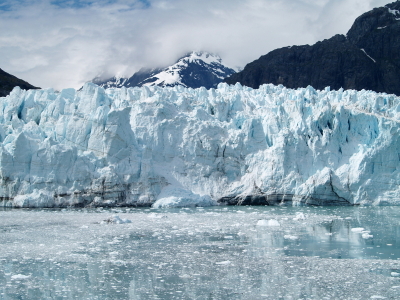
The flora of the bay ranges from mature spruce forests to delicate plant life, while brown and black bears, moose, mountain goats, sea otters, whales, seals, and a colorful array of birds inhabit this land. Most, if not all of them can be seen on a day cruise through Glacier Bay. The most spectacular part of the tour is when the boat comes face to face with the massive wall of the Grand Pacific Glacier.
The nearest town to the otherwise inaccessible park is Gustavus. Ferries don’t go to Gustavus, so the best and cheapest way to get there is with Alaska Airlines who fly in each afternoon in summer from Juneau, the state capital. The flights are met by a bus which takes you ten miles to Bartlett Cove, site of the park headquarters and the dock for the all-day cruise on the Spirit of Adventure – the principal way of enjoying the park’s wonders short of paddling. Here lies the park’s only hotel, Glacier Bay Lodge.
Glacier Bay National Park offers visitors a fantastic selection of exciting adventures. Ocean kayaking, sport-fishing, whale watching, and hiking are just a few of the numerous options available. You can also take one of many sightseeing tours by boat or airplane.
Katmai National Park and Preserve, Alaska
Katmai National Park and Preserve is situated in southwestern Alaska on Shelikof Strait. Katmai was given the status of a national monument in 1918. Its beautiful landscape, pristine waterways and abundant wildlife attract many tourists hoping to find solitude and relaxation. In addition, this rugged land offers opportunities for cross-country and short day hiking trips.
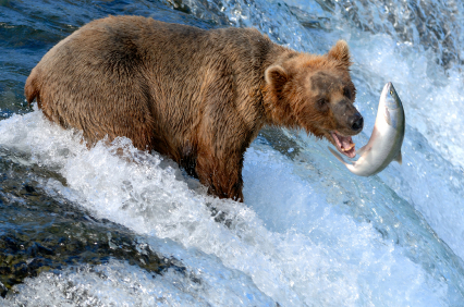
With abundant fish, remote wilderness, and a rugged coastline, Katmai National Park and Preserve is clearly one of the most beautiful parks in the nation. The flora and fauna are varied; the upper Arctic Zone is basically an alpine tundra environment. Very few trees are present here and the wildlife mainly consists of brown bears. Below the Arctic zone is the Hudsonian zone. This zone is more suitable for life, with higher year-long temperatures. This makes it suitable to support a great variety of plant and animal species.
Katmai’s various lakes, scenic valleys, and volcanic landscapes are a treat for adventure lovers. Tourists can rent canoes or kayaks and experience this vast wilderness first hand. However, the long hiking routes are best attempted only by experienced hikers with adequate preparation and skills. Inexperienced hikers should stick to the popular trails to avoid getting lost in the wilderness.
Visitors to the park should expect unpredictable weather conditions. The average summer low temperature is 44 degrees Fahrenheit. Summer usually brings in a lot of sunshine, but the weather can deteriorate very rapidly. Strong winds and storms frequently sweep the area, occasionally at speeds up to 50 to 60 miles per hour.
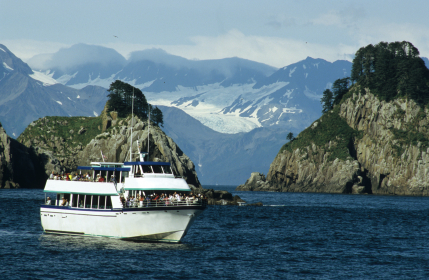
Kenai Fjords National Park, Alaska
Kenai Fjords National Park is located on the Kenai Peninsula in Southcentral Alaska. It is a magnificent 580,000-acre region of peaks, glaciers and craggy coastline. Its towering mountains are mantled by the huge Harding Icefield, feeding the three dozen retreating glaciers that have exposed the dramatic fjords after which the park is named.
Kobuk Valley National Park, Alaska
Kobuk Valley National Park is located in Northwest Alaska. The park has a variety of different landscapes, including the 25-square-mile Great Kobuk Sand Dunes, glaciers, waterfalls, rivers, and pristine freshwater lakes. The sand dunes, which were created by the grinding action of ancient glaciers, are probably the most popular features of this park.
The Great Kobuk Sand Dunes are massive structures that display the complete geological history of the park. The eastern portion of the dunes are covered with vegetation, while the crescent-shaped, unvegetated dunes are located in the western portion. These dunes represent the largest active dune field in arctic North America. The unvegetated portion includes three smaller, but equally impressive dunes – the Great Kobuk Sand Dunes, the Little Kobuk Sand Dunes and the Hunt River Dunes.
Kobuk valley has some of the most spectacular glaciers in Alaska. The waterfall fringed cliffs and deep fjords are home to many types of arctic wildlife. Sightings of whales and seals are common here. There are several hiking trails; visitors are advised to proceed on some of the trails with caution since the floor tends to be slippery and the weather, unpredictable. For backcountry hiking or camping, you should wear plenty of warm clothing.
Kobuk Valley National Park is subject to harsh winters, with high winds, snow, and rain. Summers are mild and cool. The Kobuk River typically thaws by early June, this is a good time to come if you want to witness the magnificent waterfalls in the park.
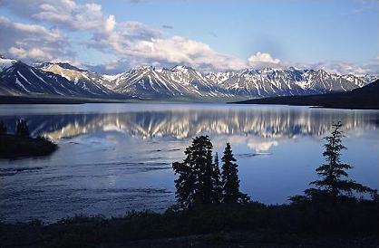
Lake Clark National Park and Preserve, Alaska
Lake Clark National Park and Preserve is a paradise for nature lovers and adventure-seekers. Lake Clark’s spectacular scenery provides a true Alaskan wilderness experience for its visitors. The Lake Clark National Park and Preserve lie about 100 miles southwest of Anchorage. Its remote location means that it is accessible only by air or on foot.
The park is home to a vast variety of animals. One can be sure to see sea otters, whales, harbor seals, black bears, moose, eagles, and spiders in this arctic wilderness. The impressive grizzly bear is also found here; visitors should be careful about approaching these potentially dangerous animals. Hunting is permitted in a portion of the park, and summer is a time when many hunters descend here. The Preserve is an area where anyone with a hunting permit may hunt.
The park contains Alaska’s volcanic belt, which is part of the Pacific “Ring of Fire”, which contains 70 potentially active volcanoes. Within the Lake Clark region itself there are four active volcanoes, at least one of which will possibly erupt in the near future. Hot volcanic gases can be seen steaming out from some of the summits.
Hiking in Lake Clark National Park can be a rewarding experience and is probably the best way to experience the park in its true natural splendor. The western foothills offer open, relatively dry tundra for backcountry hiking and camping. There are some magnificent views of mountains, glaciers, and lakes. Popular camping destinations include the beautiful Telaquana Lake, Turquoise Lake, and the Twin Lakes.
Wrangell St Elias National Park and Preserve, Alaska
Alaska’s Wrangell-St. Elias National Park and Preserve has been recognized as a World Heritage Site. As Denali becomes more crowded, people are beginning to increasingly make the trip to this more out-of-the-way park in the extreme southeast corner of Alaska. Here, four of the continent’s great mountain ranges – the Wrangell, St Elias, Chugach, and Alaska – cramp up against each other.
Everything about this park is large: glacier after enormous glacier, canyon after canyon and nine of the sixteen highest peaks in the US, all surrounded by idyllic lakes and rivers. Various kinds of animals like mountain goats, Dall sheep, bears, caribou and moose roam this land. The National Parks Service describes this park as “Incredible. You have to see Wrangell-St Elias believe it”. After witnessing this great land, you will be convinced about the truth of this statement.
As part of a visit to this park, you can go to the town of Kennicott, which is a virtual ghost town. Fascinating two-hour walking tours are conducted here. These tours start in McCarthy, the main social hub and base for adventure-seekers. Here, a number of hikes, ice climbing trips, mountain bike rides, raft trips, and even glacier skiing trips are organized.
Wrangell-St. Elias is almost entirely roadless and is essentially a trailless park. Half the fun of the trip is getting to McCarthy along 58 miles of the McCarthy Road. Stop often to admire the scenery along this route. At the end of the road, you cross the Kennicott River on a foot-bridge and continue a half-mile to McCarthy on foot, from where a shuttle bus takes you to Kennicott. There’s free camping a mile before the road ends.