Peruvian Mountains Travel Guide
The Cordillera de Los Andes it’s the world’s second-largest mountain range right after the Himalayas. You can bear in mind: about 7.240 km (some 4.500 mi) long, and an average breadth of 241 km (150 mi).
The Andes spread into several parallel ranges. In the central part of Peru, the chain divides into three distinct ranges. The Cordillera Blanca rises abruptly from the Pacific coast escorted by the Western range known as the Cordillera Negra and the Eastern one called the Cordillera Oriental. Caraz, our headquarter, is based at the north end of this system.
The Southern section, close to the Amazon basin, offers three more ranges, Cordillera Vilcabamba, Cordillera Urubamba, and Cordillera Vilcanota. Cuzco, our branch office, it’s located right there.
Extending more than 5.500 km down the mountainous Andean backbone, the Incas made the biggest native state to arise in the Southern Hemisphere, and the largest empire of ancient times, south of the equator.
Like their Roman counterpart, the Inca marched far beyond the frontiers of civilization to lead barbarian tribes. At its height, Cuzco, the imperial capital, exercised rule over northern Chile, upland Argentine, Bolivia, Peru, Ecuador, and the south of Colombia. No existing Andean realm may compare in magnitude or prosperity.
Incas made Trekking likely in Peru as resulting in their vast all-weather highway system. Major thoroughfares and trunk lines covered some 30,000 to 40,000 km. Modern technology makes Climbing and Mountain Biking possible.
Nowadays, the rich Andean culture remains as a human heritage. The friendly people, their music, colorful costumes, and tasty meals fill in the senses providing a unique experience combined with any of our programs.
Peruvian Andes
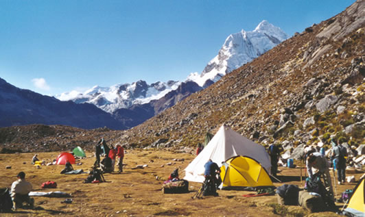
The Peruvian Andes provide a vast system of trails, from the lower valleys to the higher passes, there’s plenty of options. The weather splits the year in two, wet season, from November to March, and dry for the rest of the year, being these last months the best time for hiking and camping. Most campsites are around 3800mts, so cold temperatures must be expected at night. A maximum altitude gain of +1000mt per day is standard. The snow line lies at an average of 4800mts so vegetation still provides nice shelter at lunch spots and campsites. Villages are found up to 3600mts, with friendly Campesinos making their means of living from livestock and farming. Our Mountain Guides will help in translating the landscape and local culture as well. Cooks, Porters, and Mule Drivers will provide enough support along day walks, and our quality camping gear, to match the high altitude, will enhance comfort and safety.
The Arhuaycocha valley rewards with great views of the snowy peaks and glaciers that dwarfs us on a huge circle. In addition, a short side trip to visit the upper lake which surface is covered on icebergs.
Paron Lake
This bright-blue lake is the largest water body within the Huascaran National Park. It offers awesome views of surrounding snowcapped peaks, optional hikes along trails in the primary forest and north shore. Only 32 km East from Caraz, you can reach the lake by car in less than 2 hours driving through the granite canyon, includes 2 hours to explore and relax; it will take 2 hours for the return.

Llanganuco Lakes
These two lakes are set right at the feet of mount Huascaran, highest peak in Peru 6768 m. It offers the best option for a close view to the local wildlife, both, flora, and fauna besides spectacular views of the snow peaks around the lake. The ride from Caraz is 45 km in about 2 hours, 2 hours to explore, including an optional 4km walk to explore the primary forest, then 2 hours to return.
Puya Raimondi – Huinchus
Described as the most strange living form in the area, this rare bromeliad grows on very few places in Peru and Bolivia. It may live up to 100 years, and once it blooms, the plant dies. This spot offers in addition, a 145 km panoramic view of the glaciers, valleys, and peaks of the Cordillera Blanca. It takes 2 hours to reach the 45 km and climb 2000 m, then 2 hours to explore and 2 hours to return to Caraz.
Cañon del Pato
The Cordilleras Blanca and Negra run parallel to each other along 140 km, within this range they are set apart at an average gap of 16 km. Only 22 km north from Caraz, they get as close as barely 6 m, but still 5000 m high!. It takes 1:30 hours from Caraz, then 1-2 hours to explore and 1:30 hours for the return.
Chavin de Huantar
About 4,000 years ago, a highly developed culture raised profound in the Andes, is still uncertain where did they come from, but for sure they came with amazing knowledge, skill and, technology. A tour that starts from Huaraz and after 3 hours will reach Chavin, then a 2 hours visit to discover some of the mysteries hidden behind its stone walls. It’s a full day trip.
Tour de las Lagunas
There’s a high plateau not far from Caraz, where small ponds and puddles reflect the surrounding mountains on their still waters. It’s a perfect place for a short day walk, bird watching and relaxes. It may offer the chance to share local people’s daily life, a form of Rural Communitarian Tourism – TRC.
Cordillera Blanca
An extension to the remote Quebrada Keshu and crossing the high pass of Punta Yanayacu offers the best views of Mount Chopicalqui 6,354m, Contrahierbas 6,036m and the jagged Ulta 5,875m looming above the valley.
Trekking & Hiking in Peru
Alpamayo Full Loop – Hiking
Maybe one of the toughest hikes with several passes far beyond 4,700m. A proper previous acclimatization and quality camping gear are a must for attempting this beautiful and isolated hike.
Regarding the name of this famous 5,947m pyramidal-shape snow peak, there’s by far more to see. Trailhead it’s a Pre Inca structure, available to camp and meet the burros and prepare for the climb to the stunning Cullicocha lakes and the not less beautiful mount Santa Cruz 6,241m.
Day 1. Ground transfer to Hualcayan, trek to Huyshcash or Calamina, camp
Day 2. Trek to Cullicocha lakes, climb Osoruri Pass 4,860m, descent to Osoruri, camp
Day 3. Climb Vientona Pass 4,770m, descent to meet Alpamayo valley, gently climb to Jankarurish lake, camp
Day 4. Optional day free to explore Alpamayo Base Camp
Day 5. Climb Caracara Pass 4,830m, descent along the meadows of Quebrada Mayobamba, easy climb for Mesapata Pass 4,460m, descent to Safuna lakes area, camp
Day 6. Day visit to Pucacocha lake, right at the feet of Mounts Alpamayo and Pucahirca, trek to Huillcapampa, camp
Day 7. Climb to Pucahirca Pass 4,610m, descent to Jankapampa, camp.
Day 8. Climb to Tupa Tupa Pass 4,360m, descent to camp at Huecrucocha lake, camp
Day 9. Climb to Alto Pucaraju Pass 4,640m, descent to Tuctubampa, camp
Day 10. Climb to Punta Union Pass 4,760m, descent to Taullipampa, camp
Day 11. Descent to Llamacorral, camp
Day 12. Descent to Cashapampa. Transfer back to Caraz
Jahuacocha Trails
By far this lake translates in one shoot, all the impressions you may experience in Huayhuash. So, this easy 6-day hike offers great views of Yerupaja, Jirishanka, Ninashanka and most of the breathtaking landscapes of the northwest range.
Day-to-day itinerary: Huaraz or Caraz to Chiquian by bus, overnight, meet mule drivers and staff. Preparation for the trek, camping gear check and rest.
Santa Cruz to Vaqueria
The classic 4-day hike around mount Huandoy, several snow peaks can be seen such as Santa Cruz, Alpamayo, Quitaraju, Artesonraju, Taulliraju, Chacraraju, Chopicalqui, and Pisco. Ranging easy to moderate, just one high pass, there are so many spots to enjoy: the Jatuncocha and Ichiccocha lakes, the Quenoal, glaciers, waterfall.
Day 1. Ground transfer Caraz to Cashapampa, trek to Llamacorral, camp
Day 2. Trek to Taullipampa, camp
Day 3. Climb Punta Union Pass 4,760m, trek to Cachinapampa, camp
Day 4. Trek to Vaqueria, ground transfer to Yungay, then go on to Caraz
Alpamayo – hiking
The Arhuaycocha valley rewards with great views of the snowy peaks and glaciers that dwarfs us on a huge circle. In addition, a short side trip to visit the upper lake which surface is covered on icebergs. Dubbed as “World’s Most Beautiful Mountain”, mount Alpamayo rises as part of the Santa Cruz massif and it’s in fact, one of the most beautiful ice faces of the Cordillera Blanca. It’s located on a remote hidden ravine at the end of Quebrada Santa Cruz, so the hike to BC may take 2-3 days. It is not the challenging difficulty that inspires climbers but its magnificent setting amongst the everlasting snow peaks of the Andes. 6000 meters above sea level.
D1. Transfer Caraz to Cashapampa 2900 m (28 km, 1:10hr), hike to Llamacorral
D2. Hike to BC 4300 m at Arhuaycocha valley
D3. Climb to Col and camp at High Camp 5400 m
D4. Rest day
D5. Summit attempt 5947 m, return to High Camp
D6. Back to BC
D7. Return to Cashapampa and transfer back to Caraz
Pisco West
An easy climb that is suitable for acclimatization. Great views of mountains around, not a technical or challenging.
Day 1. Transfer Caraz or Huaraz to Cebollapampa, 3900m (end of Llanganuco valley), climb +765m in about 4hrs to Refugio Peru, 4,665m
Day 2. Early set off to cross the moraine, then get the ‘col’ 5,350m and go for the summit. Back to Refugio Peru
Day 3. Back to Cebollapampa and then drive to Caraz or Huaraz
AVAILABILITY: Winter (Southern Hemisphere)
BEST TIME: May to October
DURATION: 3 days
DIFFICULTY: Moderate
MAX: ALTITUDE: 5752 m
Inca Trail – trekking
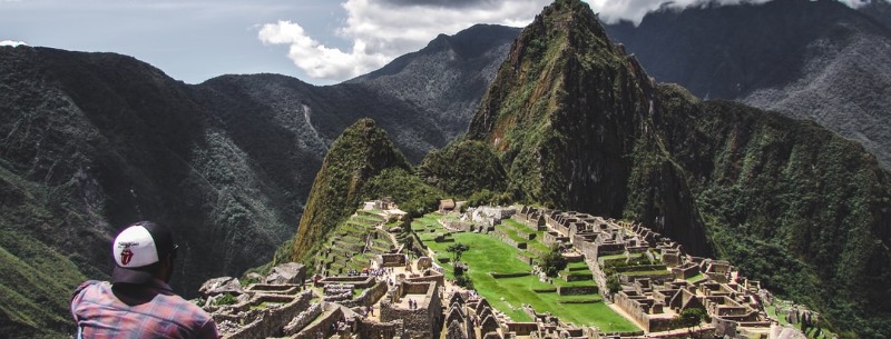
This is Peru’s best-known hike, combining a stunning mix of Inca remains, mountain scenery, lush cloud-forest, and rich subtropical jungle. More than 250 species of orchid have been spotted at the Machu Picchu Historic Sanctuary, in addition of several birds such as hummingbirds, waterfowl and Andean Condor. The highlight of the Sanctuary is the spectacled bear – a shy, herbivorous animal that is extremely rarely seen and close to extinction. In essence, the Inca Trail is a mountainous jungle hike leading to the sacred Inca city of Machu Picchu. The 45km trek is usually covered in 4 days, arriving at Machu Picchu at daybreak on the final day before returning to Cusco by train in the afternoon. Climbing Huayna Picchu is not possible unless you show up at the gate around 6 AM, so if you have plans for this, please consider staying one extra night (not included) at Aguas Calientes for a day-after second visit to Machu Picchu. (by andeantravelweb)
By far, the most known trek in South America, several reasons may support this award: cloud forest, fine stonework, Inca stairways and tunnel, exotic flowers and of course the Inca trails. A bus may take us to Km 82, which it’s the end of the road along the Vilcanota valley, sometimes a train to Km 88, both will take around 3hrs from Cuzco.
Day 1. Ground transfer Cuzco to Km 82 or 88, trek to Huayllabamba, camp
Day 2. Climb to Huarmihuañusqa Pass 4,198m, descent to Pacamayo, camp
Day 3. Climb Runkuracay Pass 4,000m, trek to Huiñay Huayna, camp
Day 4. Trek to Inti Punku and then go o to Machu Picchu, guided tour, transfer to Aguas Calientes, train back to Cuzco
AVAILABILITY: March to January (February closed). A very early confirmed booking is required.
BEST TIME: April to November
DURATION: 4 days
DIFFICULTY: Moderate
MAX: ALTITUDE: 4200 m
ELEVATION: 3100 to 4200 meters
WALKING DISTANCE: 42 km
Inca Trail (short) – trekking
This short version of the Inca Trail starts on the railway, climbing to Huiñay Huayna to spend the night. The day after, an easy walk to arrive at Inti Punku and finally a magnificent hike to Machu Picchu. A guided tour and then to Aguas Calientes to get the train to Cuzco.
Day 1. Ground transfer Cuzco to km 104, trek to Huiñay Huayna, camp
Day 2. Trek to Inti Punku, Machu Picchu guided tour, transfer to Aguas Calientes, train to Cuzco
This is one of my favorite hikes. Climb across a relatively low pass and then going mostly downhill, from the highlands to the rain forest, hot springs, bamboo, coffee plantations, wild orchids, wild strawberries, and citrus grove. In addition, an awesome less known view of Machu Pichhu and Huayna Picchu from its East flank. Arriving at Aguas Calientes by train from the remote Hidro station.
Day 1. Ground transfer Cuzco to Mollepata 2,800m, trek to Cruzpata, camp
Day 2. Trek to Soray or Salcantay Pampa, camp
Day 3. Climb Salcantay Pass 4,750m, descent to Wayraj Machay, camp
Day 4. Trek to Huinco Puco, camp
Day 5. Climb to Llactapata Pass 4,767m, descent to camp
Day 6. Descent to Hidro train station, train to Aguas Calientes, overnight at hostel
Day 7. Machu Picchu guided tour, back to Aguas Calientes, train to Cuzco
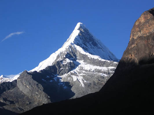
Artesonraju – hiking
Artesonraju is a beautiful snow and ice pyramid. It is fairly easy to access and is off from most international commercial groups, so rarely visited even when similar in beauty with Alpamayo.
AVAILABILITY: Winter (Southern Hemisphere)
BEST TIME: Mid June to early August
DURATION: 6 days
DIFFICULTY: D+, 800m, 45-55°, via SE face
MAX: ALTITUDE: 6025 m
ITINERARY (Suggested):
D1. Transfer Caraz to Paron lake 4200 m (32 km, 1:40hr), hike to BC 4200 m
D2. Hike to Camp Moraine
D3. Climb to High Camp 5200 m
D4. Summit attempt 6025 m, return to Camp Moraine
D6. Back to BC, return to Paron lake and transfer back to Caraz
Santa Cruz to Vaqueria
The famous trek along the Santa Cruz and Huaripampa valleys will offer great views and an ever-changing landscape. It includes the mount Huascaran 6768 m (Highest peak in Peru), Alpamayo 5947 m (dubbed to be “World’s Most Beautiful Mountain”, Artesonraju 6025 m (Paramount’s live logo) among many others. The lakes seen on the second day are habitat for several shorebirds and waterfowl birds. The third day will take you over South America’s Continental Divide. On the fourth day, the trail will lead us through friendly villages.
AVAILABILITY: All year round
BEST TIME: Mid-April to late October
DURATION: 4 days
DIFFICULTY: Easy-Moderate
MAX: ALTITUDE: 4750 m
ELEVATION: 2900 to 4750 meters
WALKING DISTANCE: 42 km o/w
ITINERARY (suggested):
D1. Set off Caraz and ride 28km in about 1:10 hours and climbing +650 m by car to Cashapampa. Hike to camp at Llamacorral 3750 m (10 km, 4-5 hours, +900 m climb).
D2. Visit the two lakes, climb to the Alpamayo Mirador and camp at Taullipampa 4250 m, (14 km, 5-6 hours, +500 m climb).
D3. Climb Punta Union Pass at 4750 m (CWD = Continental Water Divide), descend to camp at Cachinapampa 3750 m, (3 km, +500 m, 2-3 hours / 7 km, -1000 m, 4-5 hours)
D4. Hike along the village of Huaripampa to Vaqueria (5 km, 1:30 hours, -350 m / 3 km, 2 hours, +250 m) then catch our transport to take us for the second Pass (Portachuelo Llanganuco 4767 m), a visit to the beautiful Llanganuco lakes and return to Caraz (3:30 hours).
Climbing in Peru
Urus, Ishinca, Tocllaraju – climbing
Three peaks sharing the same base camp, so offering a wide range of possibilities, from Easy to Moderate/Difficult, easy access from Huaraz. It’s a perfect combination of accessibility and panoramic sceneries.
ITINERARY (suggested):
D1. Transfer Huaraz to Pashpa (13 km, end of Ishinca valley), hike to BC 4350 m
D2. Summit attempt Urus 5495 m, back to BC
D3. Summit attempt Ishinca 5530 m, back to BC
D4. Climb to Tocllaraju Camp I 5300 m
D5. Summit attempt Tocllaraju 6032 m via NW Ridge AD+, and back to Camp I
D6. Back to BC
D7. Return to Pashpa and transfer back to Huaraz
AVAILABILITY: Winter (Southern Hemisphere)
BEST TIME: May to September
DURATION: 7 days
DIFFICULTY: Moderate/Difficult
MAX: ALTITUDE: 6032 m
Huascaran – climbing
Huascaran is Peru’s highest peak, and recent news refers to be “The point farthest from the Earth’s center” and contends closely with Chimborazo. The Normal Route for Huascaran South will approach via the “The Garganta” which, depending on the season, may display great barriers of seracs.
ITINERARY (Suggested):
D1. Transfer Caraz to Musho, with donkeys, hike to BC
D2. Hike to Camp Moraine 4670 m
D3. Climb to Camp I 5900m
D4. Summit attempt and back to Camp Moraine
D6. Back to Musho, transfer to Caraz
AVAILABILITY: Winter (Southern Hemisphere)
BEST TIME: June to late August
DURATION: 6 days
DIFFICULTY:
MAX: ALTITUDE: 6768 m
Chopicalqui – climbing
Chopicalqui is sometimes dubbed the easiest 6000 peak in the Cordillera Blanca, with good reason as its south-west ridge route is only rated around AD. This makes it very popular and it can be crowded at times. However, more than one party has been turned around by snow up to the chest on the last portions of the climb, and the route gets out of condition after each heavy snowfall. Due to its proximity to the two Huascaran peaks, Chopicalqui can seem less significant than actual height would warrant, especially when seen from Huaraz. It is sometimes called the Eastern Huascaran summit. The climb offers spectacular views of neighboring summits Huandoy, Pisco, Chacraraju, Yanapaccha and both Huascaran (South and North), and most of the range is visible from the summit. (summitpost.org)
ITINERARY (Suggested):
D1. Transfer Caraz to the trailhead at end of Llanganuco valley, hike to BC
D2. Hike to Camp Moraine
D3. Climb to High Camp
D4. Summit attempt and back to Camp Moraine
D6. Back to the trailhead, transfer to Caraz
AVAILABILITY: Winter (Southern Hemisphere)
BEST TIME: July to late August
DURATION: 6 days
DIFFICULTY:
MAX: ALTITUDE: 6354 m
Mountain Biking in Peru
Hundreds of kilometers of dirt tracks make Mountain Biking in the Cordilleras Blanca and Negra a unique chance to get the best out from the region. The relatively low altitude on the northern sector enhances a better performance. Although Single Tracks, X-Country and Up Hills are physically demanding, our trips are suitable to all levels of cyclists. There’s a growing interest on our wild Down Hills and Advanced long expeditions across high passes. Serious riders will find the range rivals with the Orosi Valley in Costa Rica, Cotopaxi National Park in Ecuador, the Sorata Valley in the Cordillera Real in Bolivia and Lago Llanquihue in the Chilean Lake District. Of course, smooth-riding can be found all around Caraz as well.
When facing steep climbs, the support vehicle is often on hand. Camping facilities are transported to meet the group on each campsite and the driver becomes both, leader and mechanic. Our Bikes: Specialized Series FSR full-suspension, Rockhopper, Hardrock, Stumpjumper, all front-suspension and Titanium-axle bottom brackets, A1 Monocoque alloy and M2 Metal Matrix, X-Butted frames. The helmets, 17-vents, shell in-molding in a wide range of head shapes and sizes are available. Gloves with enough neoprene/gel pad combination to fit all sizes.
Paron Lake – Cycling – Downhill
The Paron trails offer everything from easy winding dirt roads to kilometers of intermediate slick rock. The scenery starts at the lake area, surrounded by beautiful snow peaks, waterfalls, and towering cliffs rising more than 800 m above the valley’s floor. While riding downhill you will cross friendly villages as the life around gradually changes as you descend the nearly 2000 m vertical drop.
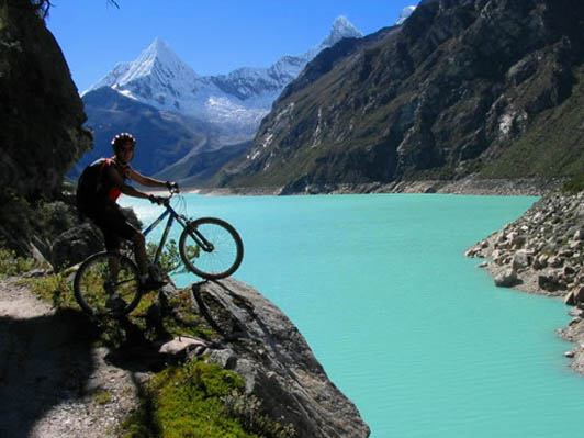
With slick rock sections, looping singletrack, sandy washes, and incredible scenery, the Paron downhill trail provides a great taste of what Cordillera Blanca mountain biking is all about. This is the perfect ride for families and offers spectacular views of the Paron River and Huascaran National Park.
TYPE: Cycletour/DH
ELEVATION: 4200 ~ 2250 m
AREA ATTRACTIONS: Huascaran National Park, Paron lake
DIRECTIONS: 32 km east from Caraz on road to Paron lake
MTB LEVEL: Intermediate
TRAILHEAD: Paron lake, 32 km east of Caraz
DIFFICULTY: Easy to Moderate
LENGTH: 32 km
TRAILHEAD ELEVATION: 4200 m
SEASON: Ideal in spring, fall, and winter; midday, best in July and August
MAX: ALTITUDE: 4200 m
Cañon del Pato – Biking
The Cordillera Blanca and the Cordillera Negra both run parallel to each other for about 140 km from south to north, with an average gap in-between of about 16 km, but suddenly, 30 km north from Caraz they get as close as only 10 m, but still rising up to 6000 m! You can ride all the way down across thus canyon, counting 35 tunnels in total and experiencing the nature of a rock formation dated 120 million years old. With slick rock sections, winding road crossing 35 tunnels that offers a view of both Cordillera Blanca and the Cordillera Negra. An easy ride for all levels
TYPE: Cycletour/DH
ELEVATION: 2250 m ~ 1850 m
AREA ATTRACTIONS: Rock formations, mountain scenery, vegetation contrast
DIRECTIONS: 1 km north from Caraz on route 3N to Chimbote
MTB LEVEL: Beginner
TRAILHEAD: Caraz
DIFFICULTY: Easy
LENGTH: 35 km
TRAILHEAD ELEVATION: 2250 m
SEASON: Best in June, July, August and September
MAX ALTITUDE: 2250 m
Portachuelo Llanganuco – Biking
The Portachuelo Llanganuco Pass is perhaps the most significant gateway of the Huascaran National Park since pre-Inca times this has been the passageway straddling the continental divide. The pass offers to bike riders a broad relatively flat corridor, between the Pacific and Atlantic watersheds. The breathtaking view from this point includes mounts Huascaran, Huandoy, Chopicalqui, Pisco, Chacraraju and Yanapaccha and the amazing emerald waters of Llanganuco lakes at your feet. With slick rock sections, several switchbacks, ever-changing landscape due to altitude loss
TYPE: Cycletour/DH
ELEVATION: 4767 m ~ 2500 m
AREA ATTRACTIONS: Huascaran National Park, Llanganuco lakes
DIRECTIONS: 15 km south from Caraz on route 3N, turn east on route to Yanama for 45 km
MTB LEVEL: Intermediate
TRAILHEAD: Portachuelo Llanganuco
DIFFICULTY: Moderate
LENGTH: 45 km
TRAILHEAD ELEVATION: 4767 m
SEASON: Best in June, July, August and September
MAX ALTITUDE: 4767 m
Puya Raimondi – Huinchus- Biking
Known as the most strange living form in the area, this rare bromeliad may grows up to 10 m and live 100 years, then blooming to finally die. An isolated dirt road climbs for 45 km west from Caraz to reach a pass called Huashta Cruz, at 4200 m, from where you can get a 145 km horizontal panoramic of the Cordillera Blanca and of course discover this enigmatic plant, just before starting the downhill to Caraz. With slick rock sections, changing landscape due to altitude loss. Represents a step up in terms of exertion and skills required, but is still enjoyable for a fit novice, includes single-track sections for Advanced riders.
ELEVATION: 4200 m ~ 2250 m
AREA ATTRACTIONS: Puya Raimondi, Huascaran National Park
DIRECTIONS: 7 km north from Caraz via route 3N, turn to west on route to Pamparomas for 38 km
MTB LEVEL: Intermediate-Advanced
TRAILHEAD: Punta Huinchus
DIFFICULTY: Moderate – Hard
LENGTH: 45 km
TRAILHEAD ELEVATION: 4200 m
SEASON: Best in June, July, August, and September
MAX ALTITUDE: 4200 m
Pueblo Libre Trails – Cross Country Biking
Pueblo Libre lies a scant 5 m from Caraz, set in a colorful desert-like range. With several roads and almost no buildings neither villages around, provides a perfect ride leading into a region that feels remote due to the silence and calms around. The views of the Cordillera Blanca glaciers, in the west background contrast with the barren soil and cactus along the trail. With slick rock sections, No great skills required but still challenging for the novice, riding up and down along dry, hot desert area.
TYPE: Cycletour/XC
ELEVATION: 2250 m ~ 2450 m
AREA ATTRACTIONS: Deserted area, mountain scenery
DIRECTIONS: Start from Caraz via route 3N to the south for 3 km, turn west on route to Pueblo Libre and ride back north to Caraz
MTB LEVEL: Easy-Moderate
TRAILHEAD: Caraz
DIFFICULTY: Moderate – Hard
LENGTH: 12 km
TRAILHEAD ELEVATION: 2250 m
SEASON: Best from April to June, hot in July, and August, September ok
MAX ALTITUDE: 2450 m
Miramar Lakes – Cross Country Biking
The Miramar area is barely 14 km NE from Caraz, it’s a huge plateau at the foothill of the Cordillera Blanca where trails around the large puddles offer great riding potential in addition to the awesome views of snow peaks and the Cordillera Negra. With slick rock sections, Some skills required for riding uphill, a bit challenging for the novice, riding up and down along dirt roads on a grassy area across forest and bushes.
TYPE: Cycletour/XC
ELEVATION: 3180 m ~ 3385 m ~ 2250 m
AREA ATTRACTIONS: Huascaran National Park, Andean villages
DIRECTIONS: A support car will set off Caraz via route 3N to the north for 1 km, turn east on route to Paron lake for 3 km, turn north towards Miramar/Queral for 8 km.
MTB LEVEL: Moderate
TRAILHEAD: Miramar Lake
DIFFICULTY: Moderate
LENGTH: 35 km
TRAILHEAD ELEVATION: 3180 m
SEASON: May to November
MAX ALTITUDE: 3385 m
Huascaran Full Loop – 2d/1n Biking Expedition
A route crossing Portachuelo Llanganuco and Punta Olimpica pass riding through the central section of Callejon de Conchucos, a colorful region not spoiled by massive tourism. You will visit the cities of Yanama, San Luis, Chacas and Carhuaz. The snow-covered landscape, the suspended glaciers, and the hidden lagoons among forests of quenoales enrich each passage of this beautiful 2-day circuit around Peru’s highest peak. A basic family-run hostel will provide a comfortable and cozy stay at Chacas. Due to high altitude, most of the way up will be handled with a support vehicle, making of this a sort of double downhill ride. With slick rock sections, Moderate skills required, challenging for a novice, riding down along dirt roads at very high altitude..
TYPE: Cycletour/XC
ELEVATION: 4767 m ~ 2500 m / 4850 m ~ 2645 m
AREA ATTRACTIONS: Huascaran National Park, mountain scenery
DIRECTIONS: By car, start from Caraz via route 3N to the south until Yungay (15km), turn east on route to Yanama until reaching Portachuelo Llanganuco Pass (45km).
MTB LEVEL: Moderate – Advanced
TRAILHEAD: Portachuelo Llanganuco Pass
DIFFICULTY: Moderate – Hard
LENGTH: 120 km
TRAILHEAD ELEVATION: 4767 m
SEASON: Best in June, July, August and September
MAX ALTITUDE: 4850 m
Callejon de Conchucos – 3d/2n Biking Expedition
The less touristic valley of Mosna River, on the East flanks of the Cordillera Blanca, offers a unique opportunity to explore and discover its many attractions such as hot springs, ancient pre-Inca remains, beautiful lakes, villages perching-like on the green hills, canyons and rich gastronomy. With slick rock sections, Moderate skills required, some challenging for a novice, riding up and down along dirt roads.
TYPE: Cycletour/XC
ELEVATION: 4516 m ~ 3100 m
AREA ATTRACTIONS: Huascaran National Park, mountain scenery
DIRECTIONS: Start from Caraz via route 3N to the south, pass Huaraz and Catac, then turn to SE climbing towards Tunel Kahuish.
MTB LEVEL: Moderate
TRAILHEAD: Tunel Kahuish
DIFFICULTY: Moderate – Hard
LENGTH: 90 km
TRAILHEAD ELEVATION: 4516 m
SEASON: Best in June, July, August, and September
MAX: ALTITUDE: 4516 m
Huaraz, Punta Callan, Sechin, Casma 2d/1n Biking Expedition
The old road from the Andes to the desert coast, now almost paved, will take you from a pass at 4200, from where you can enjoy spectacular views of the Cordillera Blanca, then riding all the way down to the coast at sea level, arriving in Casma, and discovering the mysteries of Sechin pre-Inca site. Paved, no great skills required but is still physically challenging for anyone, riding along the hot dry desert area.
TYPE: Cycletour/XC
ELEVATION: 4200 m ~ 25 m
AREA ATTRACTIONS: Deserted area, mountain scenery
DIRECTIONS: Start from Huaraz via route PE-14 heading west until Punta Callan Pass (30km).
MTB LEVEL: Easy-Moderate
TRAILHEAD: Huaraz
DIFFICULTY: Moderate – Hard
LENGTH: 130 km
TRAILHEAD ELEVATION: 4200 m
SEASON: Best in June, July, August and September
MAX: ALTITUDE: 4200 m