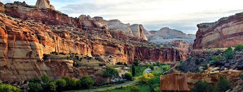
Untouched Desert at Capitol Reef National Park
The area of southern Utah desert is known as Capitol Reef National Park is one of the newer discoveries in the United States, with paved roads leading to the park constructed only in the 1960s. The giant ripple of the Earth’s crust known as Waterpocket Fold in Capitol Reef is full of Puebloan history in the form of petroglyphs, while tourists flock to the park for photography, hiking, and camping on these scenic grounds. Read on to find suggestions on where to stay, find beautiful photos of Capitol Reef National Park, and things to do within the park.
Things to Do in Capitol Reef
Activities, hiking, biking, and photography in the park
Some of the best sites within Capitol Reef are not on the paved roads, but beyond them in the brush, on the trails, and on top of the amazing “reef.” Get up close and personal with the wildlife and step away from the parking lot!
Petroglyphs
The park has a trail leading to ancient petroglyphs called Petroglyph Pullout. This trail is 1 1/2 miles from the visitor’s center and affords an intriguing view of the centuries-old artwork on the rock.
Mountain Biking
Mountain biking is one of the best ways to see Capitol Reef. With several trails from easy to strenuous, you can count on seeing a good portion of the park via mountain bike.
Rock Climbing
Capitol Reef is becoming increasingly popular for rock climbers. The area has unique formations and a variety of challenges. Permits are not required, but you need a backcountry permit to camp overnight.
Photography
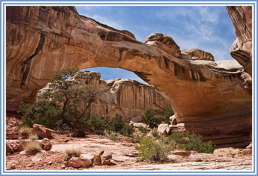
As you can see by the photos at the link above, the park has incredible photography opportunities all over.
Facts About Capitol Reef National Park
Visit this Utah National Park gem!
- The park was established as a National Park in 1971.
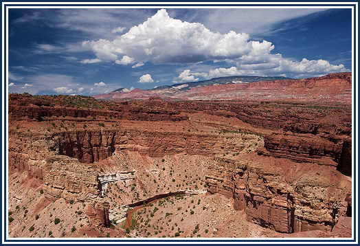
- Capitol Reef National Park encapsulates the Waterpocket Fold, a 65 million-year-old piece of the Earth’s crust that is often described as a “wrinkle.”
- The word “reef” comes from a local term used to describe large, impassable rocks.
- The word “capitol” to describe the park was used to describe the large white domes that line the top of the folds.
- August 2, 1937, the park was declared a National Monument by President Roosevelt.
- The park was once the edge of shallow sea millions of years ago.
- Torrey, Utah, is the town closest to the park (8 miles).
Where to Stay Near Capitol Reef
Hotels and accommodations near the park
Torrey, Utah, is the town closest to the park. It’s around 8 miles from the park, while I-70 runs through parts of the protected area. There are plenty of accomodations to choose from in the town of Torrey. Here are some hotels and lodging in town:
Sandstone Inn & Restaurant, Torrey, UT
Formerly Wonderland Inn, this #3 hotel in Torrey on Trip Advisor has clean, comfortable rooms, a hot tub, and the perfect easy accessibility to the park gate.
Austin’s Chuckwagon Lodge
The beautiful grounds of Austin’s Chuckwagon lodge are a welcome retreat from the desert heat, with clean grounds and a pool nestled amongst trees and shade. Rated #1 on Trip Advisor!
Best Western Capitol Reef Resort, Torrey, UT
Just a few miles from the gates of the park, this #2 rated hotel on Trip Advisor is an excellent deal, with efficient and friendly staff and comfortable rooms.
Days Inn Capitol Reef, Torrey, UT
At the end of Scenic Route 12 with free wifi! This hotel is a great bargain and very affordable.
Mammals in the Park
What mammals can you expect to see within the park?
The dry washes, high cliffs, streams and rocky plants of Canyonlands National Park provide homes to many animals and mammals. The National Park Service has listed some of the most common mammals roaming the park to be the Gray Shrew, Western Pipistrel (a species of bat), Black Bear, Ringtail, Badger, Spotted and Striped Skunks, Mink, Shorttail Weasel, Coyote, Red Fox, Gray Fox, Mountain Lion, Bobcat, Yellowbelly Marmot, Rock Squirrel, Valley Pocket Gopher, Ord’s Kangaroo Rat, Beaver, Porcupine, and Whitetail Jackrabbit.
Utah Road Trip
See the scenic roads of Utah!
Utah is a state like no other. With five major National Parks, and a dozen or more other monuments, state parks and protected areas in just the southern area alone, the state is a vacation on its own. This guide will show you some of the best roads to travel, where those hidden beauties are, and how to plan out your Utah road trip.
History, Geology, and Geography of Capitol Reef National Park
Read all about how the park was protected, how it was formed, and where exactly it is!
Capitol Reef National Park is a United States National Park, in south-central Utah. It is 100 miles (160 km) long but fairly narrow. The park, established in 1971, preserves 378 mi² (979 km²) and is open all year, although May through September is the most popular month.
Called “Wayne Wonderland” in the 1920s by local boosters Ephraim P. Pectol and Joseph S. Hickman, Capitol Reef National Park protects colorful canyons, ridges, buttes, and monoliths. About 75 miles (120 km) of the long up-thrust called the Waterpocket Fold, a rugged spine extending from Thousand Lake Mountain to Lake Powell, is preserved within the park. “Capitol Reef” is the name of an especially rugged and spectacular segment of the Waterpocket Fold near the Fremont River. The area was named for a line of white domes and cliffs of Navajo Sandstone, each of which looks somewhat like the United States Capitol building, which runs from the Fremont River to Pleasant Creek on the Waterpocket Fold. The local word reef referred to any rocky barrier to travel.
Until relatively recently, Capitol Reef and the Waterpocket Fold country comprised one of the most remote corners of the lower 48 U.S. states. Easy road access came only with the construction in 1962 of a paved State Route 24 through the Fremont River Canyon.