2024 Samoa Visitors Guide
A third of our planet is the Pacific Ocean. Away out in that undulating blueness, 2,600 miles southwest of Hawaii and 1,800 miles northeast of New Zealand appear the islands of Samoa.
Samoa itself is said to mean “sacred center”. It is an archipelago strung along an east-west axis roughly 14 degrees south of the equator. According to geologists, the coral-fringed islands are the tops of volcanoes that rose from the seafloor, hissing and streaming lava as crustal plates shifted below. An older story is that this is where the world began as the creator, Tagaloalagi, first called forth earth, sea, and sky from the rock. Then, the Samoan legend continues, he made the first human being.
Anthropologists also view the Samoan Islands in terms of origins. Language links and artifacts suggest that the first distinctly Polynesian culture may have developed here some 3,000 years ago. Over the centuries that follow, seafarers in double-hulled sailing vessels stocked with pigs, dogs, and fruits spread that culture across much of the Pacific, colonizing points as distant as Hawaii, New Zealand, and Easter Island.
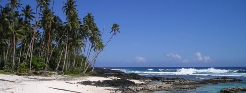
During the modern colonial era, the western end of the Samoan chain fell under German control, then New Zealand’s. In 1962, it became the independent nation of Western Samoa now known simply as Samoa. The US took possession of the eastern half of the archipelago in 1900. Its largest island is Tutuila, where the navy maintained a base at Pago Pago Harbour until 1951. Sixty miles east rise Ofu, Olosega, and Ta’u, the islands collectively known as Manu’a, revered in legend as the birthplace of Polynesia and long a powerful kingdom in its own right. Ofu, built of soaring black stone, it is robed in the rainforest and further softened by summit mist from which waterfalls spill back down towards the sea.
Together with another small island and two coral atolls, Tutuila and the Manu’a group make up the US territory of American Samoa with a current population of about 64 thousand. Overseen by the Department of the Interior, the territory has its own legislature, an elected governor, and a nonvoting representative to the US Congress. Today, it also has a 10,500-acre national park, a quarter of which extends from the beaches out to sea.
The United States’ only parkland in the Southern hemisphere was created to protect three kinds of communities under pressure from modern forces. First is the paleo-tropical rain forest, where the flora and fauna stem mainly from southeast Asia, forming habitats unique within the US park system. Second, is the Indo-Pacific coral reef, markedly richer in species than reefs in other ocean regions. Third, bound to both rainforest and reef, is the indigenous Polynesian culture.
Ta’u is formed by the tallest peak in American Samoa, 3,170 foot Lata Mountain. The clouds that almost perpetually shroud the volcano’s heights may lose as much as 300 inches of rain yearly, while the sunlit lower slopes steam in greenhouse profusion.
The Samoan flying fox roost in profusion on these volcanoes. It is normally active during the day, soaring over the forest canopy like a hawk. Folktales cast these animals as guardians of the forest. Ecologically, they filled that role. The only land-dwelling mammals other than the sheath-tailed bat to occur naturally in Samoa, they helped to maintain the woodlands by pollinating and distributing the seeds of a large proportion of the island’s vegetation.
Although the park may be small by continental standards, its marine segments run along almost 15 percent of American Samoa’s coastline while the land pieces add up to more than 16 per cent of the territory’s total land area of 77 square miles. Here on the island’s steep slopes, the rainforest’s structure has remained largely intact – spared the logging and intensive agriculture that, in Samoa and other South Pacific Islands with more accessible terrain, have shed silt and aggro chemicals onto coral reefs offshore.
The reef in the park along Ofu is a filigreed labyrinth of at least 64 different varieties of corals, from azure-tinged mushrooms to chartreuse vases. Boulder corals hundreds of years old bulge as big as whales. One type of staghorn coral resembles stalagmites rising from a tabletop.
Thick-trunked futu, or fish poisoned trees, border the beach with sprays of big purplish, bat-pollinated flowers. Each flower blooms for a day and a night or two then drop loose. Villagers used to gather the fruits and mashed them together and cast the mixture into shallow waters to capture fish stunned by the poison. This is a place that one always dreamed of but have given up hope of ever finding. As long as this is a park, that kind of hope need never dim.
A GLIMPSE OF SAMOA
The main islands of the Samoan group, like the Hawaiian group, are high islands, the summits of a great range of volcanic mountains.
The distance from Rose Atoll on the east, to the west end of Savaii, is about 290 nautical miles. To the westward of Savaii, there are shoals, in which Pasco Bank, about 90 miles W.N.W. of Savaii, has 50 feet of soundings showing depths of 15,000 to 18,000 feet. Between Upolu and Tutuila there is a small gap with a depth of nearly 6,000 feet.
Savaii, at the west end of the main chain, is the largest, highest, and geologically youngest island. It measures 47 land miles east and west, with the greatest width of 27 miles. The area is given as 703 square miles. On top of a 6,000-foot dome there are several small peaks or cones, the highest elevation being about 6,094 feet.
There has been recent volcanic activity, an extensive flow having descended the north side in 1750; a smaller one in 1902; and another crater on the N.E. was active from 1905-1911. Matavanu crater still has steam issuing from cracks in 1924. The slopes of Savaii are well forested.
Upolu measures 47 by 8 to 12, maximum 15, land miles, area 430 square miles. The length of the island is traversed by a range of mountains of rather uniform height and uniform slope with higher elevation about 3,608 feet. Along the ridge are numerous craters, some of which, like Lanutoo, contain crater lakes. The lowlands are fertile and have been cultivated, including plantations of cacao, rubber, bananas, but principally coconut palms. In the middle of the northern side is located Apia, the chief city, business center, and capital of Western Samoa. It does not have a good harbor and landing must be made in small boats.
Between Savaii and Upolu are two small islands. Apolima is a tuff crater, open on the north; its floor is a little above sea level. The inner slope is gradual and forested; the outer precipitous and bare of vegetation. Its area is about 2 square miles, elevation 472 feet. Manono is lower and sandy, elevation about 200 feet, with a few volcanic outcrops. It is connected with the N.W. coast of Upolu by a fringing reef. Springs are brackish, and the few inhabitants must catch rainwater in concrete tanks. Off the east end of Upolu are four small islets, one of which, Nuutele, is a breached tuff crater, like Apolima, about 400 feet high, the flat floor of which has been cultivated.
Tutuila is about 18 miles long by 5 or 6 miles wide, with a land area of 40.2 square miles. A mountainous ridge extends nearly the length of the island, with spurs on both sides; the highest elevation, Matafao Peak, 2,141 feet. A drowned valley on the south side forms Pago Pago Bay, the best harbor in the South Seas. South of the eastern end is a circular tuff crater islet, Aunuu, about 275 feet high.
Between 60 and 70 miles eastward of Tutuila are three small islands, together called the Manua Group, and with a combined area of 18 square miles. The largest is Tau, 14 square miles; steep, forested slopes; greatest elevation, 3,056 feet. The other two islands, Ofu, and Olosega (pronounced o-lo-seng-a for the “g” in Samoa is pronounced “ng”– now Swains Island) are separated by only shallow water. The elevation of Ofu is given as 1,587; of Olosega 2,095. All three are covered with trees and shrubs, and large areas have been planted to coconut palms. Rose Atoll lies 78 nautical miles eastward from Tau.
The climate of Samoa is tropical, moderated by strong S.E. trade winds from May to November. During the balance of the year (Samoan summer and fall) the winds are variable, with severe storms and occasional hurricanes. This is called the wet season, although in places, like Pago Pago, where mountains intercept the trade winds, it may rain throughout the year. Yearly rainfall: Apia 108 inches (from 69 to 173); Pago Pago, 197 inches (130 to 284). The greatest monthly average during January or February (Apia 16; Pago Pago 21.7); least in July or August (Apia 2.8, Pago Pago 7.8). February is the warmest month at Pago Pago, average 86.28 degrees F; July the coolest, average 80.21 degrees F. Relative humidity is high: 70 to 90 percent during the wet season; 40 to 60 percent during the dry.
The land fauna and flora are oceanic in character, derived from the west, and, like Hawaii, with little or no American affinity. There are no native mammals except a rat and some bats. There are only 34 species of land birds, of which 14 are endemic, including such forms as the famous tooth-billed pigeon, fruit doves, kingfishers, and white-eye. The usual species of sea birds are present. Of reptiles, there are one land and four sea snakes and ten or a dozen kinds of lizards. There are some 800 species of flowering plants, of which 1/3 are endemic; 260 species of ferns, 400 species of mosses, 200 fungi and 180 lichens.
The Samoans are a Polynesian people of fine physical type. In culture, they are closely related to the people of Tonga and the Ellice (Tuvalu) and Tokelau Islands. They differ in some respects from the Tahitians, Marquesans, Maoris, and Hawaiians; but all are thought to have come from common stock which migrated eastward from south-eastern Asia.
Their food consists of fish, bananas, breadfruit, taro, yams, pigs, chickens, various marine animals; and of recent years they have developed a liking for such foreign foods as canned salmon and beef, rice, tea, and biscuits. Agriculture is carried on by natives in some clearings on the edge of the forest.
All Samoans, old and young, love to dance; their Siva being accompanied generally by singing. Native clothing consists of a lava-lava or wrap-around kilt, formerly of tapa or fine mats; in addition, the women wear a smock-like upper garment, and the men an undershirt when in public.
Brought to the attention of Europe in 1722 by Roggeween, Samoa was visited by several early voyagers, and later traders and missionaries. Pago Pago Harbour was ceded to the United States as a naval coaling station in 1872.
A treaty between Britain, Germany and the U.S.A. on June 14, 1889, made Samoa neutral. Trouble between rival chiefs made it necessary another treaty, November 14, 1899, by which kingship was abolished, islands west of 171 degrees were given to Germany and those east to the United States. Western Samoa was occupied by a British expeditionary force, August 29, 1914; and it was made a mandate of New Zealand by the Treaty of Versailles.
Samoan government takes the form of meetings of chiefs and heads of family, accompanied by ceremonial kava drinking. The American Naval Government wisely has left this local government, under three native district governors. Naval doctors have greatly improved health conditions in American Samoa, and also British trained native practitioners guard the health of Western Samoa, so that the native population is on the increase, and despite tropical diseases, health conditions are quite good. The 1937-1938 population was given as: Western Samoa 54,160 natives and 3,600 others; American Samoa, 11,906.