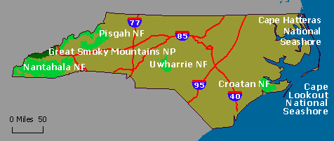
The North Carolina Forests and Parks include areas managed by the U.S. Forest Service and the National Park Service. North Carolina has four National Forests; Croatan, Uwharrie, Nantahala, and Pisgah. The Forests encompass portions of the Appalachian Mountains with elevations as high as 6,684 feet. Countless cold rushing streams offer some of the country’s best trout waters. National Forest land in the piedmont area offers miles of hiking, mountain biking, and camping opportunities. The eastern shore national land offers a unique habitat for plant life including the Venus Fly Trap. The National Park property includes the famous Great Smoky Mountains known for their rolling mountains, craggy rock ledges and deep moist gorges lined with ferns, mosses, lichens, Catawba rhododendron, and mountain laurel. North Carolina also offers National Battlefields, Monuments, Lighthouses, and Forts scattered across the state.
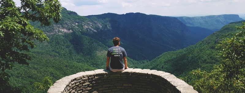
Visitors to the National Forests and National Park sites in North Carolina will find many recreational opportunities. Boating, warm and cold water fishing, hunting, hiking, horseback riding, mountain biking, wildlife and plant observing, viewing history, camping, and picnicking are a few of the most popular activities.
Climate
North Carolina has a temperate climate with mild winters and long fall and spring months. Summers can be hot and humid, especially in the piedmont and coastal plain region, which don’t get relief from coastal breezes or higher elevations. The state receives various amounts of precipitation ranging from 30 to 100 inches of rain annually. Transylvania lies in southwestern North Carolina and is deemed the land of waterfalls.’ This mountainous region receives nearly 8 feet of rain each year.
Great Smoky Mountains National Park
Great Smoky Mountains National Park, in the states of North Carolina and Tennessee, encompasses 800 square miles of which 95 percent is forested. World-renowned for the diversity of its plant and animal resources, the beauty of its ancient mountains, the quality of its remnants of American pioneer culture and the depth and integrity of the wilderness sanctuary within its boundaries, it is one of the largest protected areas in the eastern United States.
Great Smoky Mountains National Park is America’s most visited national park providing recreation for 10 million visitors each year.
National Forests of North Carolina
The National Forests of North Carolina include four national forests covering 1.2 million acres, from the mountains to the sea.
Croatan National Forest
The Croatan is located along the coast. The Croatan’s 160,000 acres have coastal forests, saltwater estuaries, bogs, and raised swamps, called pocosins. Bounded on three sides by tidal rivers and Bogue Sound, the forest is defined by water. The Forest borders the White Oak, Neuse and Trent River, and to the south lie the Bogue Sound and the Atlantic Ocean. Blackwater creeks originate deep in the forest. All this water provides a variety of fishing and canoeing, as well as a diversity of wildlife – from deer, black bears and turkeys to wading birds, ospreys and alligators. The Croatan’s estuary and swamp areas offer visitors a unique view of a national forest. Insectivorous plants, such as the Venus flytrap and crustaceans, such as crab and shrimp, relish the Croatan’s environment.
A swimming beach is located at the Neuse River just south of Fishers Landing. The Neusiok Trail travels 22 miles through the east side of the Croatan National Forest. It goes from a cypress-lined, sandy beach on the Neuse River, south through bottomland hardwoods and thick pocosin, to a beautiful estuary of the Newport River. The Croatan offers numerous recreation opportunities including camping, fishing, boating, canoeing, swimming, as well as simply enjoying nature. There are six designated camping areas on the Forest; three are primitive sites, with very limited facilities.
Nantahala National Forest
The Nantahala is located in the Appalachians of southwest North Carolina. The Nantahala is the largest of the four forests, totaling 528,541 acres. The Nantahala sits adjacent to Great Smokey Mountains National Park. The Nantahala lies in the mountains and valleys, between Waynesville and Murphy. Three designated Wildernesses and two Wild and Scenic Rivers are located on the Forest. Three picturesque reservoirs in beautiful mountain settings provide boating, water-skiing, fishing, and swimming. The Nantahala is the home of the Joyce Kilmer Memorial Forest, one of the nation’s most impressive remnants of old-growth forest.
Mountain Waters Scenic Byway and Cherohala Skyway both lead through the Nantahala. Mountain Waters is a 61-mile drive through Appalachian hardwood forests, rural countryside, and two spectacular river gorges complete with waterfalls. The Cherohala Skyway winds along the crest of the Unaka Mountains, from Robbinsville, North Carolina to Tellico Plains, Tennessee.
There are several scenic waterfalls in the Highlands area: Whitewater Falls, Silver Run Falls, Bridal Veil Falls, and Dry Falls. Whitewater Falls is the highest falls east of the Rockies. Bridal Veil is a 120 foot falls you can drive your car under. You can walk behind the 75-foot Dry Falls without getting wet.
The Appalachian Trail leads through the Nantahala as well as the Pisgah National Forests. The Bartram Trail is a national recreation trail that travels across the mountains of South Carolina, Georgia, and the Nantahala in North Carolina.

Pisgah National Forest
The Pisgah National Forest’s 500,000 acres stretch along the eastern edge of the mountains of western North Carolina. The Pisgah borders the east end of Great Smoky Mountains National Park. The Pisgah’s mile-high peaks, cascading waterfalls, rivers, and heavily forested slopes offer visitors a variety of opportunities for outdoor recreation. People can hike on more than 600 miles of trails and view scenic waterfalls, plants, and wildflowers.
The Blue Ridge Scenic Byway and the Forest Heritage Scenic Byway both lead through the Pisgah. Popular attractions along the Forest Heritage Scenic Byway include Looking Glass Falls, Sliding Rock, three picnic areas, two campgrounds and the Cradle of Forestry in America. In addition to Looking Glass Falls, other scenic waterfalls on the Forest include Moore Cove Falls, in the Brevard area and Elk Falls, northeast of Burnsville.
The Appalachian Trail leads through the northwest end of the Pisgah. Max Patch Mountain is described as a crown jewel of the Appalachian Trail, which crosses the mountain’s summit. For the casual walker, a gravel road comes to within a half-mile of the 4,629-foot summit and a spectacular panoramic view. About 216 miles of the Mountains-to-the-Sea Trail cross the mountainous Pisgah and Nantahala National Forests from Blowing Rock on the Blue Ridge Parkway, south to Balsam Gap.
Uwharrie National Forest
The Uwharrie sits in the middle of the state. Although the Uwharrie National Forest, with just over 50,000 acres, is the smallest national forest in North Carolina, it packs in great recreation opportunities. The Uwharrie is located in a portion of North Carolina known as Piedmont (meaning foot of the mountains). The 1,000-foot Uwharrie Mountains that cross the forest are considered to be the oldest mountain ranges in North America. Some of the first gold mined in North America came from this region.
Denson’s Creek Nature Trail, behind the Uwharrie Ranger Station, is a self-guided loop that reaches Denson’s Creek. For more of a challenge, try the 20-mile Uwharrie Trail or the connecting 9.5 mile Dutchman’s Creek Trail. A designated National Recreation Trail, the Uwharrie Trail is to Piedmont what the Appalachian Trail is to the mountains, only on a shorter scale.
A 15-mile network of mountain bike trails begins from the Wood Run Trailhead. In the Badin Lake area are nearly 150 miles of horse trails. Two primitive horse camps provide open fields and toilets. Hunters benefit from the healthy populations of deer, turkeys, squirrels, and rabbits. Many enjoy colorful songbirds, magnificent wildflowers and the sight of bald eagles over Badin Lake in the winter.
North Carolina National Wildlife Refuges
The Wildlife Refuges in North Carolina cover areas of upland forests, wetland forests, marshlands, rivers, coastal estuaries and more. These refuges provide essential habitat for wildlife and fish populations. Most were established to protect and enhance wetlands for the conservation of migratory birds; some were established to provide habitat for the Nation’s endangered species.
Alligator River National Wildlife Refuge
The vast expanse of undisturbed swamp forest and wetlands on this 152,000-acre refuge contains much important wildlife and ecological resources. Since clear-cutting, peat mining, and agricultural conversion have developed much of the Pamlico Peninsula, this area remains one of the most remote and diverse swamps in eastern North Carolina.
Cedar Island National Wildlife Refuge
Today the Cedar Island National Wildlife Refuge consists of 14,480 acres and approximately 11,000 acres of irregularly flooded, brackish marsh and 3,480 acres of pocosin and woodland habitat.
Currituck National Wildlife Refuge
The refuge is comprised of five main tracts scattered along the barrier island. The 1,142-acre Currituck Marsh tract and the 247-acre Station Landing Marsh tract are the two most northern tracts. The 1,390-acre Swan Island tract is the next track to the south. The 380-acre Monkey Island tract, which includes several small islands in Currituck Sound, is located just north of a 50-acre tract owned by The Nature Conservancy and an adjoining 335-acre tract owned by the North Carolina National Estuarine Research Reserve. The two most southern tracts are the County Marsh tracts, totaling 54 acres, which are located northwest of the Currituck Beach Lighthouse in Corolla, NC.
Mackay Island National Wildlife Refuge
The 8,646-acre Mackay Island National Wildlife Refuge is on the north side of Currituck Sound, which has long been recognized for supporting significant migratory waterfowl populations and sport fishery resources.
Mattamuskeet National Wildlife Refuge
Located in eastern North Carolina in Hyde County, the Mattamuskeet Refuge consists of more than 50,000 acres of water, marsh, timber and croplands.
Pea Island National Wildlife Refuge
Pea Island National Wildlife Refuge was established as a wintering area for the greater snow goose and other migratory waterfowl. The refuge is located on the north end of Hatteras Island, a coastal barrier island and part of a chain of islands known as the Outer Banks.
Pee Dee National Wildlife Refuge
Pee Dee was established with the purpose of providing sanctuary and wintering habitat for migratory birds.
Pocosin Lakes National Wildlife Refuge
The predominant vegetation type of the refuge is southeastern shrub bog, which is also known as pocosin. This ecosystem is characterized by a very dense growth of mostly broadleaf evergreen shrubs and scattered pond pine. The dominant species of the bottomland hardwood forest are black gum and Carolina ash, with smaller components of red maple, water tupelo, loblolly pine, and bald cypress.
Roanoke River National Wildlife Refuge
The refuge includes forested wetlands in the lower 130 miles of the Roanoke River from the fall line at Weldon, NC downstream to the Albemarle Sound near Plymouth, NC.
Swanquarter National Wildlife Refuge
Swanquarter National Wildlife Refuge, located on Pamlico Sound in Hyde County, North Carolina. Approximately 8,800 acres are included in the National Wilderness Preservation System.