Maine National Parks & Forests Guide
The national forest and national parkland located in Maine offers some of the most pristine wilderness and beautiful natural sights remaining in America. The national agencies manage homesites for hundreds of species of birds, amphibians and reptiles, countless animals and beautiful large game mammals.
 The forests are desolate wonders of what once covered the entire United States. Wildlife and forest management are the primary concern for these agencies with recreation trailing second. The Appalachian Trail has its terminus at Baxter State Park, Mt. Katahdin.
Attractions
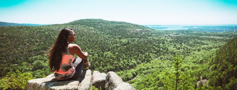
The largest attraction to the northernmost New England state is its natural beauty. Maine occupies 3,700 miles of coastline and thousands of acres of inland waterways and mountains. The tourism board separates the state into eight segments, which we will follow closely in the next paragraphs. The southern coastal area is split into Southern Coast, Greater Portland, and Midcoast regions. This area is characterized by rocky and sandy beaches, lighthouses and Colonial-era fortresses. The mid coastal region has a jagged shoreline that illustrates the forces of glacial scouring that can be found throughout the state.
New England villages with Colonial and Romantic era architecture pervade the region and add to its unique character. A concentration of the state population lives in this very accessible part of Maine. There also is a concentration of state parks, public reserve lands and state historic sites maintained within the lower coastal area of Maine. White Mountain National Forest is located in the Western Maine Mountains area of the state offering a more remote recreational environment than the busy Down East Acadia National Park area.
Recreation
Recreation opportunities in Maine are as diverse as the terrain. Inland lakes in this state number close to 2,500 and support a myriad of water-oriented activities. If sailing, swimming, and fishing in coastal waters is your pleasure, this state can satiate your desires. Hiking, camping, and biking are popular during the warmer months, as are cross-country and downhill skiing, snowshoeing, and skating in the winter. Acadia National Park and White Mountain National Forest offer an array of outdoor activities. White Mountain tends to have more rustic and backcountry-style amenities while Acadia tends to offer more comfortable amenities. Each offers unsurpassed scenery, fishing opportunities, and hiking and biking paths. Whitewater boating and winter skiing are popular in White Mountain, while tour boating and sightseeing are more popular at Acadia.
Climate
The climate in this northern state is cool year-round. Summer high temperatures average near 75 degrees F, but often reach 90 degrees in the southern portion of the state. Summer evenings are cool and a sweater is usually necessary. Fall is usually dry with crisp days and cool nights. Expect nighttime temperatures to reach into the high 30s, especially in the northern regions of the state. This weather brings spectacular foliage colors between early September and late October. Winter can be long and gray in Maine, but recreation opportunities abound to beat the cold. Average daytime temperatures from December through March remain close to 20 degrees F. Nighttime temperatures can dip below zero. Spring is usually wet with snowmelt and rains. Moderate temperatures between 45 and 60 degrees F can be expected during the day.The areas experience cold and snowy winter months. The average temperature is 10 – 18 degrees Fahrenheit ( -12 to -8 Celsius). Winter traveling requires planning ahead and being prepared for snow-covered roads. Summer brings cool, pleasant breezes with temperatures averaging 68 degrees Fahrenheit (20 Celsius).
Location
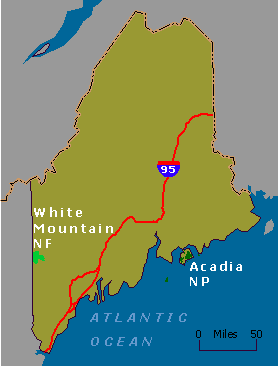
Maine is located on the northeastern tip of the United States. It is bordered by New Hampshire, the Northern Atlantic Ocean and Quebec, Canada. White Mountain National Forest is located in the Western Maine Mountains Region off SRs 103 and 5 and US 2. Acadia National Park is located in the Down East Region south of Bangor. The Appalachian Trail enters Maine from New Hampshire at Mount Carlo. It stretches across some of the trail’s most rugged territory to reach its terminus on Mt. Katahdin in Baxter State Park.
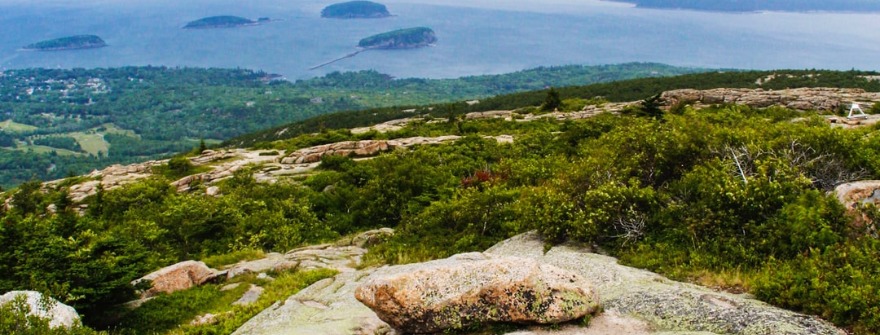
Acadia National Park
Acadia National Park is comprised of over 40,000 acres. On this national land rests two air quality monitoring sites, approximately 20 pounds, and lakes and 26 mountains. Over 3 million people visit annually to view the spectacular scenery, enjoy the protected lands and study the 273 species of birds, 11 species of amphibians, 7 species of reptile, and over 40 species of mammals. Created some 350 million years ago, this coastal boreal community has attracted people for thousands of years.
Directions
Getting there… Take I-95 to Bangor, then take Route 1A east to Ellsworth. In Ellsworth take Route 3 to Mount Desert Island. Or, take I-95 to Augusta, then Route 3 east to Ellsworth, continuing on to Mount Desert Island.
>> Check out or FULL Guide to Acadia National Park
Roosevelt Campobello International Park
The Roosevelt Campobello International Park is a unique example of international cooperation. This 2800 acre park is a joint memorial by Canada and the United States and a symbol of the close relationship between the two countries. Here are the cottage and the grounds where President Roosevelt vacationed, the waters where he sailed, and the woods, bogs, and beaches where he tramped and relaxed. The Roosevelt Campobello International Park was established under an agreement signed by President Lyndon B. Johnson and Prime Minister Lester B. Pearson on January 22, 1964. The Roosevelt Campobello International Park was officially opened on August 20, 1964.
In the 2,600 acres of the Park at the southeast end of Campobello Island, more that memory is preserved. The Roosevelt “cottage” is there, the simple wicker furniture and the knick-knacks of a summer home. But beyond the gardens are the bogs and the fog forests, the bays and shoals – all the natural beauties the Roosevelt family knew – protected now for others to enjoy. Although isolated by geography, [Campobello] has entered the lives of two nations as a place to invite any soul and to refresh any weariness with a sense of continuity and endeavor.
The natural beauty of Maine and New Brunswick, Canada was not lost on Franklin D. Roosevelt who made a summer home on Campobello Island, just off the United States and Canadian border, in New Brunswick’s Bay of Fundy.
Maintained today by the National Park Service, the Edmund S. Muskie Visitor Center, the Roosevelt Cottage and the beautiful flowering gardens offer visitors a chance to share in the peacefulness of this unique setting.
Directions
From I-95 take Route 1A east to Ellsworth and then Route 1 to Whiting Village. Take Route 189 to Lubec and across the FDR Memorial Bridge to Campobello Island.
Saint Croix Island International Historic Site
The National Park Service preserves Saint Croix Island International Historic site as a monument to the beginning of the United States and Canada. It was here that Pierre Dugua Sieur de Mons with his company of men established a French settlement in 1604-05. In cooperation with Parks Canada, the National Park Service educates the public about that heroic effort, its context, and its consequences.
The site is focused on establishing a quiet atmosphere of respect meant to promote contemplation of the heroism and suffering of the French colonists in 1604Ð05. A short walk to the interpretive shelter looking onto the estuary and St. Croix Island is recommended. Visitors are offered an interpretive panel, picnic tables, and accessible vault toilets. Drinking water is not available.
The site of an early attempt at French colonization by Pierre Du Gua de Monts, in 1604, Saint Croix Island – sometimes locally referred to as Dochet Island – is located in the middle of the Saint Croix River, separating the United States and Brunswick, Canada.
Visitation to the uninhabited island is discouraged by the National Park Service, and available only by private boat. However, tourists are welcome at the extensive Saint Croix Visitor Center, located on the United States mainland, and at an unmanned outdoor exhibit, operated by Parks Canada, on the opposing Canadian side.
Directions
Saint Croix Island is 8 miles south of Calais, Maine, on U.S. Route 1 and can be reached either by Route 9 from Bangor or from points north or south along U.S. Route 1.
White Mountain National Forest
White Mountain National Forest offers spectacular scenery in a northern mountain environment. The high elevations stretching above the tree line offer a rugged and often times cold experience for the traveler. Wildlife is abundant throughout all areas of the forest. Designated wilderness and scenic areas promote wildlife propagation. The visitor should keep in mind that recreation is second to the preservation effort within the USDA property.
The White Mountains are known for their majestic slopes, rushing streams, conifer forests, and sudden extremes in weather. The ranges and ridges of White Mountain National Forest are the highest mountains in the Northeast. Maine’s Speckled Mountain reaches an elevation of 2,906 feet and Caribou Mountain tops at 2,850 feet. Miles of hiking trails, coldwater brook trout streams, and two campgrounds characterize Maine’s portion of the White Mountains.
Hiking, fishing, hunting, camping, wildlife viewing, and scenic driving are the most popular outdoor recreations enjoyed on Maine’s 47,000-acre portion of White Mountain National Forest. Downhill skiing and cross-country skiing are allowed by permit only. Several designated wilderness areas prohibit logging, road building, vehicular, and bicycle travel.
Saint John River Valley Acadian Culture
Between the United States and Canada runs the St. Johns River, and along its shores, and in “back settlements”, live the Maine Acadians. Shared beliefs and experiences that tie them to the river, the land, and their families, is the basis for Maine Acadian Culture.
Through the Maine Acadian Heritage Council – a group of museums, historical societies, cultural clubs, and towns – the National Park Service aids the people of the Saint John River Valley.
Directions
Saint John Valley is located 200 miles north of Bangor, Maine at the northern terminus of U.S. Route 1. From I-95 use the Sherman or Smyrna Mills exits for Route 11 to Fort Kent, or use the Houlton exit for U.S. Route 1 north.
Appalachian Trail Maine to Georgia
Approximately 2,168 miles in length, the Appalachian Trail is a National Scenic Trail, extending from Springer Mountain, Georgia to Mount Katahdin, in Maine’s Baxter State Park.
Although the hiking trail, which traverses portions of 14 states, is not on the Maine National Parks list, as it makes its way through the state it is maintained by the National Park Service and protected by a public right-of-way.
Directions
A hike along the Appalachian Mountain Trail can begin at either end or at points in between. When determining which direction to travel, hikers are mindful not only of the anticipated climate but of the mid-October closing of Baxter State Park, where the trail has its northerly end.