Scenic Byways in Georgia
Georgia offers one National Scenic Byways, the Tamiami Trail Scenic Byway, and seven state-designated scenic byways. Surrounded by the scenic and natural beauty of the Chattahoochee National Forest, the Russell-Brasstown Scenic Byway winds its way through the fertile valleys and mountain gaps of the southern Appalachians.
Pine forests and rolling pastures dominate the views along the Monticello Crossroads Scenic Byway as it runs through Jasper County. The Ridge and Valley Scenic Byway provides a chance to experience the varied terrain of northwest Georgia. Mountain overlooks and fertile farmlands can be found along the 51-mile Ridge and Valley Scenic Byway. The South Fulton Scenic Byway consists of a 29-mile loop in south Fulton County which highlights the rural character and lifestyle of the surrounding area. It is situated among rolling hills, forested ridges, and serene pastures.
Byways provide access to numerous cultural, historical, natural, recreational and scenic sites. Some of the most popular activities along the byways include hiking, camping, picnicking, biking, fishing, photographing scenery, viewing historic sites and of course scenic driving.
Monticello Crossroads Scenic Byway
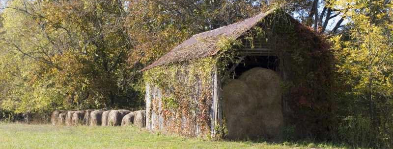
The route passes through woodlands, pastures, pecan groves, and rolling grasslands.
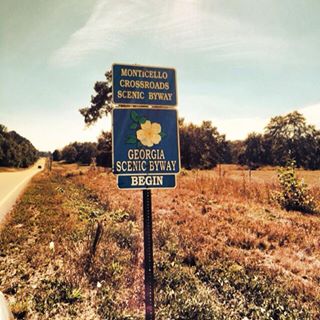 Pine forests and rolling pastures dominate the views along the Monticello Crossroads Scenic Byway as it runs through Jasper County. This 29-mile Byway emphasizes the rural and historic qualities of the area as it follows State Highways 11 and 83 headings north from the town of Monticello. Native Americans, as well as evangelical Methodist Circuit Riders, once used these routes as they crossed the state. Highway 83 was also part of the Seven Island Stagecoach Road that ran from Augusta to New Orleans and the Natchez Trace. Several individual structures, as well as the central business district of Monticello, have been listed on the National Register of Historic Places. The Monticello Crossroads Scenic Byway is known for it’s Cultural, Historical, Natural, Recreational and Scenic Attractions.
- Designation: Georgia State Scenic Byway
- Fees: No fees to drive the byway.
- Length, One-Way: 28 Miles (46.67 Kilometers)
- Time: Allow at least one hour for driving and a visit in
Location – This byway is located in central Georgia, in the Piedmont Region. The Monticello Crossroads Scenic Byway is made up of State Routes 11 and 83, from the southern city limits of Monticello to the Jasper County border.
Ridge and Valley Scenic Byway
This byway provides a chance to experience the varied terrain of northwest Georgia as it travels U.S. 27, State Highways 156 and 136, and rural county roads.
As the name implies, the Ridge and Valley Scenic Byway provides a chance to experience the varied terrain of northwest Georgia. Mountain overlooks and fertile farmlands can be found along the 51-mile Byway as it travels U.S. 27, State Highways 156 and 136, and rural county roads. Outdoor activities ranging from hiking, camping, and picnicking to fishing and hunting can be enjoyed at the Keown Falls Scenic Area, the Pocket, and John’s Mountain Overlook and Wildlife Management Area. The surrounding countryside also holds the histories of the native Cherokee Indian Nation; Civil War battles; and early settlers whose farmhouses built in the 1800s still stand. The Ridge and Valley Scenic Byway is known for it’s Historical, Natural, Recreational and Scenic Attractions.
- Designation: Georgia State Scenic Byway, USFS Scenic Byway
- Fees: No fees to drive the byway.
- Length, One-Way: 50 Miles (83.33 Kilometers)
- Time: Allow three hours for driving and side trips
Location – This byway is located in northwest Georgia, in the Highlands Region. The Ridge and Valley Scenic Byway is a loop using U.S. 27, Thomas Ballenger Road, Armuchee Road, State Route 136, Walker County Road 723, Pocket Road, John’s Creek Road, Lover’s Lane, Floyd Springs Road, and State Route 156.
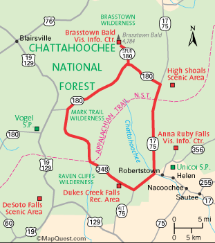
Russell-Brasstown Scenic Byway
Surrounded by the scenic and natural beauty of the Chattahoochee National Forest, the Russell-Brasstown Scenic Byway winds its way through the fertile valleys and mountain gaps of the southern Appalachians.
From the breathtaking vistas found atop Brasstown Bald (Georgia’s tallest mountain) to the cooling mists of the byway’s numerous waterfalls, scenic wonders abound in this region of North Georgia. Outdoor enthusiasts can spend days enjoying the area’s many recreational opportunities, such as trout fishing in cool mountain streams and hiking along the Appalachian Trail. The National Forest setting also provides a protected habitat for hundreds of native plant and animal species. It is also an ideal destination for viewing spectacular fall color. With its scenic natural landscapes and wonderful recreational activities, the Russell-Brasstown Scenic Byway is a popular destination for a mountain getaway.
- Designation: Georgia State Scenic Byway, National Scenic Byway, USFS Scenic Byway
- Fees: No fees are required to drive the byway.
- Length, One-Way: 40 Miles (66.67 Kilometers)
- Time: 3 hours
Location – This byway is located in northern Georgia, in the Highlands Region. There are several routes along this byway.
- From Atlanta: Take I-85 north to I-985, then take I-985 north to SR 384. Go north on SR 384 until you reach SR 75, and head north along SR 75 through Helen. The byway begins at a junction with SR 75 Alternate.
- From Gainesville: Take SR 11/US 129 north from Gainesville to SR 75 in Cleveland. Then travel north on SR 75 through Helen. The byway begins at a junction with SR 75 Alternate.
- From Toccoa: Take SR 17 west from Toccoa to a junction with SR 75 near Helen. Then take SR 17/75 north through Helen. The byway begins at a junction with SR 75 Alternate.
- From Dahlonega: Take U.S. 19 north to a junction with SR 180 at the right. Then take SR 180 east to SR 348. he byway begins at a junction of SR 180 and SR 348.
- From Clayton: Take U.S. 76 west to SR 17/75. Then take SR 17/75 south to a junction with SR 180. The byway begins at a junction of SR 17/75 and SR 180.
- From Hiawassee: Take SR 17/75 south to a junction with SR 180. The byway begins at a junction of SR 17/75 and SR 180.
South Fulton Scenic Byway
This 29-mile loop in south Fulton County highlights the rural character and lifestyle of the surrounding area.
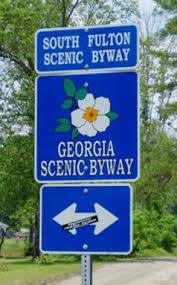 Situated among rolling hills, forested ridges, and serene pastures, the South Fulton Scenic Byway uses Cochran Mill Road, Hutcheson Ferry Road and State Highway 70 to guide visitors through this quiet corner of metropolitan Atlanta. In addition to the historic communities and farmhouses found along the Byway, visitors can enjoy Cochran Mill Park, Cochran Mill Nature Center, and the nearby Chattahoochee River, which provides many recreational opportunities.
- Designation: Georgia State Scenic Byway
- Fees: No fees are required to drive the byway.
- Length, One-Way: 29 Miles (48.33 Kilometers)
- Time: Allow one hour for driving and photo opportunities
Location – This byway is located just southwest of Atlanta, in the Piedmont Region. The South Fulton Scenic Byway forms a loop using State Route 70, Hutcheson Ferry Road, and Cochran Mill Road.
—–
Byways provide access to numerous cultural, historical, natural, recreational and scenic sites. Some of the most popular activities along the byways include hiking, camping, picnicking, biking, fishing, photographing scenery, viewing historic sites and of course scenic driving.