Guide to Colorado’s National Monuments
Colorado National Monuments are very unique. Each has its own history of the creation of these impressive areas. There were many early explorers and settlers who admired the beauty of the monuments and rallied to protect the natural wilderness. Most of the monuments are found in the western part of the state where major upheaval of the continental plates occurred millions of years ago.
At this time, the territory was tropical and water covered land. Dinosaur National Monument, at the orange marker, is located in northwest Colorado is a testament to the species that roamed the tropical forests of the state.
The Hovenweep National Monument and the Canyon of the Ancients is located in the southwest corner of the state, indicated in yellow and purple. It was established to preserve and protect the villages of ancient Native Americans in Utah and Colorado. You notice that Hovenweep is at the Utah, Colorado state line.
The Colorado Monument, stands in the central/western part of Colorado, as indicated by the aqua marker. You are transported to another world. Here you will see massive rock formations in a landscape that looks like an alien planet.
There is much to see in the state of Colorado. Visiting these national monuments will take you back to the beginning of life on earth. Hard to believe from the creation of these natural sculptures that the state was once a tropical paradise. The past is preserved as it was millions of years ago in these haunting and wild areas of western Colorado. A visit here is well worth it.
A lot of driving is required to get to the monuments, as they are scattered along the western border of the state. Plan a central destination as your base of operation and explore each at your leisure.
Dinosaur National Monument
Dinosaur National Monument is located in the northwest corner of Colorado, the orange marker shows the location. It is the most important discovery of the state’s prehistory. Millions of years ago, the territory was flat, lush, and a tropical zone. Water was everywhere and the plants and animals thrived.
Climate change brought a severe drought and the waters dried up. Ancient plants and dinosaurs died of thirst. The last water hole was located in eastern Utah, near the Colorado border. When the rivers started running again, the remains of the dinosaurs were swept along the river bed and buried in the sand. Rock and other sediments in the river flow buried the fossils for millions of years.
A rare find, the rocks and rock formations of the monument were left here billions of years ago from mountains north of the area, called the Uinta Mountain Range. When the tectonic plates of the continents started to push together, the upheaval formed the Rocky Mountains and sent rocks rolling into the valleys below. Many more millions of years went by and about 10,000 years ago, the first Native Americans came to live in the area. This is proven by the many artifacts found near the monument and surrounding areas.
Spanish explorers Dominguez and Escalante explored the area for Spain in 1776. In the early 1800s, fur trapper and trader William Ashley traveled down the Green River through the monument in search of beaver. Adventurer John Wesley Powell and his expedition, traveled down the river in 1869, past the monument and on to the Grand Canyon.
Early settlers to Colorado found the area around the monument too rough to build homes and farms, so many homesteaded the area around the great rock formations. Earl Douglass was the first person to find dinosaur bones in the area. This discovery was made on August 17, 1909. With word of the find, archaeologists swarmed to the area and a great quarry of remains was uncovered.
Nine distinct dinosaurs were found and remains were sent to museums around the country, of which, the Carnegie Museum became very interested in preserving the quarry. The museum officials lobbied Washington for protection of this rare find and finally in 1915, President Woodrow Wilson granted 80 acres as a national monument. More discoveries in the quarry deemed it necessary to add more land to the monument and in 1938, 200,000 additional acres were included. The canyons of the Yampa and Green Rivers were now protected by the monument status as well.
In 1950, the government decided to build two dams, one on the Yampa/Green River and another in Utah. This would have destroyed the fragile ecosystem of the monument. Many groups and private citizens nationwide protested to Washington, and Congress canceled the construction of the dams.
However, one dam, the Flaming Gorge Dam, was built further upstream of the rivers, well out of the monument boundaries. But the damage had already been done by fur trappers, settlers, ranchers, and the construction of the Flaming Gorge Dam. Bear, buffalo and bighorn sheep, animals that had flourished here, were gone from the monument.
Today, the terrain is still rugged, but beautiful in its wildness. Visiting the monument you can see spectacular views from Harding Hole Overlook, Echo Park and the Canyon of Lodore.
The cliff face at Echo Park displays the remains of ancient petroglyphs carved into the rock by early Native Americans. Steamboat Rock at Echo is one of the many rock formations viewed here. Many fossils are exhibited at the Visitor’s Center at the monument entrance. To get to Dinosaur National Monument, head west on Interstate 70 from Denver and beyond.
Exit north on Hwy. 13 at the town of Rifle and continue toward the town of Meeker. At Hwy. 64, head west to the town of Dinosaur and follow the signs to the park.
Hovenweep National Monument
Hovenweep National Monument, (purple marker), is located in far eastern Utah. But since it is part of the Canyon of the Ancients National Monument in Colorado, (yellow marker), we are including it as one of the state’s national monuments. The monument was created to protect the Native American villages in Utah and Colorado.
There are many villages that make up the monument. On the Utah side, the Cajon Group and the Square Tower Group contain several buildings, towers and kivas. The Holly Group, located in Keeley Canyon is in Colorado. The Boulder House and Tilted Tower are built on large boulders. It is amazing how these were constructed given the precarious nature of climbing the canyon walls.
Another group, the Horseshoe Group in the Horseshoe Canyon is home to Horseshoe Tower and Horseshoe House. The tower is the largest structure in the area. In Hackberry Canyon, the Hackberry Group was found to have the largest number of occupants. It is east of Horseshoe.
The most eastern site in Hovenweep is known as Goodman Point. Archeologists believe that between 200-450 A.D. the buildings suggest a large community of people. Between 900-1300 A.D. it became much more populated. In 1899, Goodman was the first archaeological site in the area and protected by the federal government. Today, most of this site has collapsed and has been buried.
The famous Smithsonian Institute received word of this find and sent a man named Feweks, to survey the area in 1917. The institute lobbied Washington to put the entire area under federal protection. In 1923, President Harding signed Hovenweep into being. You can still visit the monument, though tourism is almost nonexistent. The ruins are buried in a remote part of the Colorado Plateau, but to visit here you can walk in the shoes of the Ancients from 200 A.D.
The best way to get to Hovenweep is the southern route. Take Interstate 25 south to Hwy. 50 west. Follow it to Hwy. 160 and southwest for 2-3 hours. You will arrive in Cortez. Follow the signs to Canyon of the Ancients National Monument and on to Hovenweep.
However, if you happen to be visiting the other national monuments in the western part of Colorado, you can make the trip following Hwy. 50 from Grand Junction to Hwy. 160 south through the Rio Grande National Forest, into Durango and then on to Cortez and the southwestern corner of the state.
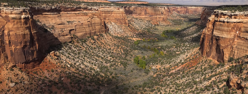
Colorado Monument
The Colorado Monument, located in western Colorado (the aqua marker), displays some of the most rugged and awe-inspiring rock formations millions of years old. The official name is the Colorado National Monument. Sitting in the Uncompahgre Plateau, geologists have found that the monument was formed by at least two events. The first one, some 300 million years ago, pushed the plateau skyward some 10,000 feet and eventually, over millions of more years, receded back to sea level.
Then when the Rocky Mountains were formed, around 70 million years ago, the plateau was shot upward again, and finally rested to the present day. Rain and flooding on the mesas of the Uncompahgre ran down to join the Colorado River and canyons and erosion were formed in the Colorado National Monument.
The first humans to arrive in this area were the ancient Native Americans, around 1700 A.D. Later the Ute Indians settled this area beginning in 1300 A.D., and there they lived until around 1881 when they were moved to reservations in Utah and other parts of Colorado.
And again, the first explorers were Dominguez and Escalante who were searching the western part of the territory for gold in the name of Spain in 1776. As usual, anywhere there is a river, fur trappers arrived and in 1839 a trapper named John Roubdeau set up the first trading post.
More settlers arrived and realizing the proximity of water and the lush grasses, named the area the Grand Valley. In October 1881, newcomer George Crawford built a house in the valley and helped found the town of Grand Junction.
When towns are established the railroad isn’t far behind, especially to lay tracks to the Pacific. In 1882, the Denver and the Rio Grande railroad arrived and set up a train depot. The first conservationist in the area was John Otto in 1906. He marveled at the beauty and ruggedness of the land and decided to build trails up and around the monument area.
His love of this wild piece of Colorado, sent him to Washington to lobby for the area to become a national park. However, this was not to be. President William Taft signed into being the Colorado National Monument instead, on May 24, 1911.
The trails that Otto built were hiking trails and fairly treacherous for wagons. In 1912, a wagon road was establish called Trail of the Serpent. With the coming of automobiles, the government decided to have a road constructed through the monument called Rim Rock Drive.
The building started in 1933 and finally was finished in 1950. The lull in construction was because of World War II from 1942-49. Protection of the monument as been ongoing for a century-plus. Many of the trails and rock formations keep the names that John Otto gave them.
Otto re-introduced buffalo to the area in 1926 because they were killed almost to extinction by settlers and the railroad for meat. As with the mountains of Colorado, other wildlife such as bears, mountain lion, elk, and mule deer can be found here. Also, the monument, which is downstream from Dinosaur National Monument, held the fossilized remains of dinosaurs outside the area. The discovery was made by Dr. Elmer Riggs in 1900.
Many canyons exist at the monument. Wedding Canyon and Monument Canyon hold some of the most interesting rock formations such as the Pipe Organ, Kissing Couple, Praying Hands, and the Coke Ovens. Hiking is permitted at the monument but you must stay on the designated trails. The Rock Rim Drive gives a panoramic view of the canyons and rock formations with overlook points along the way.
Driving to the monument is fairly easy, located at the central western border of Utah. Take Interstate 70 west to Grand Junction, continue west to Fruita and follow the signs to the Colorado Monument.