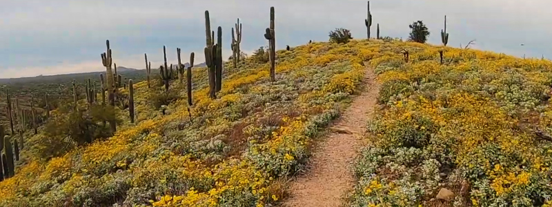
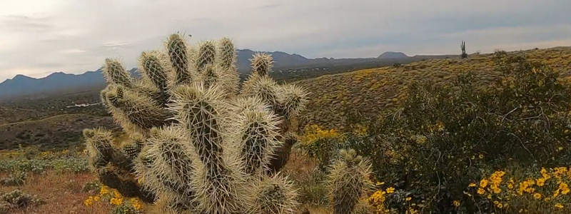
This area is a well-kept secret to visitors to the Scottsdale area. At over 21,000 acres, McDowell Mountain Regional Park is the picturesque desert jewel of northeast Scottsdale about 10 miles north of Fountain Hills. The views here are amazing with its mountain backdrops, stacked granite boulders, large stands of gigantic Saguaros, and desert flora with frequent sightings of Arizona wildlife including deer, coyotes, and javelina.
The park is particularly gorgeous during the spring when bursts of color saturate the park with wildflowers and cactus blooms. Ancient Hohokam Indians once called this area home from the 1100s to about 1450 when they mysteriously disappeared. Using irrigation from the confluences of the nearby Verde and Salt Rivers, the ancient civilization of early Native Americans grew agricultural crops and hunted for survival.
Today, the natural beauty within McDowell Mountain Regional Park is much the same as it was thousands of years ago. Gazing across the many picture-postcard views can only imagine the experiences of the early inhabitants. They are now gone but left the feast of visual treasures to generations that follow. Evidence of their existence is scattered in the park as well as the McDowell Mountain Preserve that borders the park.
Over 50 Miles of Multi-Use Trails
All trails are open to hiking, horseback riding, and mountain biking unless otherwise indicated. The trails range from very easy to strenuous and have lengths ranging from 0.5 to 15.3 miles of a round trip. Some are more acclimated to biking and horseback riding while others are made for light hiking. An easy hike is the ‘North Trail” at 3.1 miles. The most conducive for riding a horse is the “Pemberton Trail” at 15.3 miles. Trails are as follows:
- Bluff: 2.2 mi (3.5 km)
- Coachwhip: 1.0 (1.6 km)
- Dixie Mine: 5.6 mi (9.0 km)
- Eagle: 0.4 mi (0.6 km) round trip, hike only (Youth Groups only),
- Granite: 3.5 mi (5.6 km)
- Hilltop: 0.5 mi (0.7 km) round trip, hike only
- Lousley Hill: 1.2 mi (2.0 km) round trip, hike only
- North: 2.9 mi (4.7 km) round trip, hike/bike only
- Nursery Tank: 0.6 mi (0.9 km) round trip, hike only/barrier-free
- Pemberton 15.3 mi (24.9 km) loop
- Scenic: 3.5 mi (5.6 km) (subject to flooding)
- Scout: 0.8 mi (1.3 km) round trip, hike/bike only
(Youth Groups only) - Stoneman Wash: 4.3 mi (6.9 km) (subject to flooding)
- Tonto Tank: 2.7 mi (4.3 km)
- Wagner: 1.1 mi (1.8 km) hike/bike only
Competitive Mountain Biking Tracks
There are three “loop competitive tracks” at the park that combined offer about 15 miles. The “Long Loop” is primarily for average riders but can be used by all. The “Sport Loop” is for intermediate mountain bikers and the “Technical Loop” is designed for the expert with tight, swooping turns, steep inclines, and very technical descents. The Competitive Track is a race site for various competitive events. The distances below reflect round-trip distances from the trailhead.
- Long Loop: 8.2 mi (13.3 km)
- Sport Loop: 3.0 mi (4.8 km)
- Technical: 2.9 mi (4.6 km)
Horseback Riding and Horse Staging Area
Many of the trails in McDowell Mountain Regional Park permit equestrians riding their own horses. There is a horse-staging area at the park located at the end of Shallmo Drive that intersects with the main park drive just past the park visitor center. The most popular horse trail is Pemberton Trail with a length of 15.3 miles.
Picnicking at the Park
There are two picnic areas that combined feature 88 picnic sites. Ironwood is open all year and Paloverde is closed from May to August. Conveniences are all right at the picnic sites including a picnic table, cooking grills, restroom, and a playground for the children. All sites are first-come, first-serve.
Camping and RV Parking
A developed campground provides 76 individual camping sites for both tent and RV camping. Each campsite has a parking area that will accommodate a 45 foot RV. Camping sites include a picnic table, barbecue fire ring, and electrical hookup. Water is available and conveniences include restrooms with flush toilets and showers. The south loop of the campground has handicap accessible restrooms.
There are three group campgrounds. The main group campground includes a 3-acre parking area that will accommodate up to 30 RV units for either day use or overnight camping. Reservations require a commitment of six units for dry camping. There is a covered ramada with six picnic tables, a large barbecue grill and a large fire ring.
The Four Peak Staging Area is more primitive and ideal for overnight group campers with horses. Restrooms with flush toilets and hot showers are available. McDowell Mountain Regional Park also has a Youth Group Area for large youth groups including the Boy Scouts, Girl Scouts, and other youth groups. This area has port-a-potties, picnic tables, a large fire ring, and a flagpole.
Map and Directions
There are several ways to get to McDowell Mountain Regional Park depending upon your origination point. The about map to the parks will show the quickest routes from anywhere in the Phoenix and Scottsdale area.
Guidelines and Considerations
All trails are multi-use unless otherwise indicated. Trail etiquette is required and please respect the preserve. Fees are required. Contact the Maricopa County Parks Department for current fees. Educational events occur on an ongoing basis. Safety is always a concern. Dress appropriately for the weather and activities. Always have plenty of water when hiking, biking or horseback riding, particularly during the hotter summer months. Remember to let others know where you are going and when you will return.
The park is a large area, so please stay on the trails. During the summer, try and limit hiking, biking, and horseback riding to the earlier morning hours or in the evenings. Closed-tip shoes are a must. Arizona receives low rainfall, but the monsoon season can bring storms with lightning quickly. Pets are okay providing they are on a leash at all times. Remember to give your pet water often. Open fires could be restricted during dry fire periods. Camping and fires outside the designated areas is prohibited. See Scottsdale Weather, Climate, and Temperature Charts help plan your outdoor activities and recreation.
For More Information
Check the McDowell Mountain Regional Park website within the Maricopa County Parks Department for additional information, online group camping reservations, entry fees, camping fees, annual passes, and events.
McDowell Mountain Regional Park
16300 McDowell Mountain Park Drive
(480) 471-0173
Topics covered: Scottsdale AZ Bike Riding, Horseback Trails, RV Camping in Scottsdale, Arizona, Tent Camping, Competitive Mountain Biking, Easy and Strenuous Hiking in the Scottsdale Area.