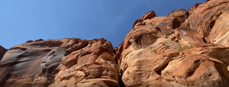
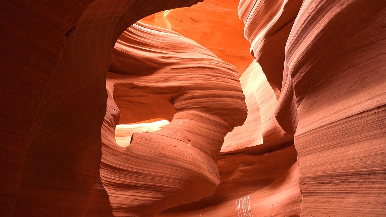
Stunningly beautiful. A sacred place. An unimaginable blend of natural, glowing colors. Carved by nature over millions of years by flowing water and wind, it’s like a collection of real-life paintings. Located just east of Page, Arizona, Antelope Canyon is entirely underground on the Navajo Indian Reservation. Beneath the landscape, rays of sunlight penetrate sporadic openings at midday creating at the artful collection of illuminated colorful sandstone. It is like a natural cathedral of spiritual beauty.
A photographer’s dream. No other slot canyon has been photographed more than Antelope Canyon. Midday when the overhead beams of sunlight cascade into the canyon makes for the best photoshoots. The summer months between May and September are the best periods when the most powerful sun rays strike the canyon creating the most vibrant and brilliant colors. Stand in the shaded areas to take your photographs of light beams that make the walls glow with brilliant color. Throwing sand into the rays creates some interesting shots.
For safety, all visitors must be accompanied by authorized guides. Seasonal waters of Antelope Creek flow through both canyons and drain from the south, into nearby Lake Powell. There is an imminent threat of canyon flooding when rain falls in the surrounding Navajo land. Drainage that sources from dozens of miles away, without warning can present immediate flash flood danger. The rainiest months in the canyon area are generally August and September.
Two Separate Canyons
Hidden beneath the barren desert landscape are two different canyons with mystical chapel-like carvings of majestic and narrow passages between the most astounding sandstone formations you will ever experience. The sun’s rays cascade through cracks in the desert surface highlighting showcasing some of its most precious specimens. Antelope Canyon remains forever secretive in location, magnanimous in the presence, and sacred to the Navajo.
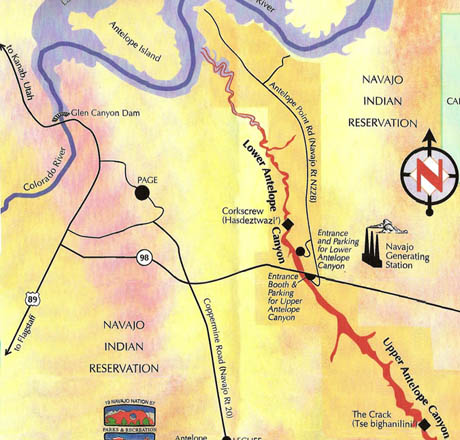
The “Upper Canyon“, called “Tse’ bighanilini” by the Navajo meaning “the place where water runs through rocks”, is the most popular of the two canyons and one of the most photographed spots in America where the stream bed runs120 feet below the surface. Upper Antelope Canyon is often called “The Crack“. “Lower Antelope Canyon“, or Hasdestwazi- Navajo for spiral rock arches, is also known as Corkscrew Canyon.
Both slots carry the seasonal waters of Antelope Creek, draining from the south, into Lake Powell, and both carry imminent threat when rain falls on the Navajo land. This threat may seem deceptively minute when rains aren’t falling directly overhead; however, drainage coming from dozens of miles away will bombard these peaceful earthen temples in an instant. Safety now requires that all visitors must be accompanied by a trained, expert tour guide.
Although Antelope Canyon canyon is not steeped in traditional human history, the staggering beauty of the walls themselves provides stories no human could ever create. Stepping inside the narrow crevice of The Crack (Upper Antelope), you are surrounded by enormous walls, reaching 120 feet high. From the right angle, the walls evaporate and strong, silent faces lean forward, whispering amongst themselves the secrets of millenniums long since passed.
Winding through the inner reaches of the upper canyon, incandescent rays of the Arizona sun shoot through like laser beams to the sandy creek bed. The power of these beams causes the gentle curving walls to glow red hot, like so many burning logs in a desert campfire, while the shaded nooks are painted in softened shades of blue and purple. In Lower Antelope Canyon, a feast of camera-loving spirals swirl and wind along the sides of this shallower, V-shaped work of natural art. In its attempts to remain hidden, access to the lower canyon is significantly more challenging, with uneven terrain, long narrow stretches, and metal stairways. More photographers than tourists will venture through this sandstone cathedral, in search of the elusive capture that stirs the myriad colors and shapes of these walls to life on film.
Earth, sun, wind, and water all actively participated in the formation of Antelope Canyon, and other slot canyons that populate the land surrounding the Grand Canyon. The Navajo Sandstone, worn down to a smooth finish from eons of flash flooding and erosion, holds tight to the truth of its origin. Pronghorn Antelope roamed the lands, and thusly left early explorers with no other obvious option but to name this particular accordingly. Members of the LeChee Chapter of the Navajo Nation-state that the land around this area was used as winter grazing ground for herds of cattle, however beyond that, very little is known of early occupation of this area.
Directions To Antelope Canyon
Antelope Canyon is located about 130 miles north of Flagstaff, Arizona on Highway 89. It is about 4 miles east of Page, Arizona, and just south of Lake Powell on the Navajo Indian Reservation. The following map to Antelope Canyon shows you the way. Click the map for an enlarged detailed view.
More information
Visit Navajo Parks and Recreation for tour information and a seasonal schedule of tour times.
Lake Powell Navajo Tribal Office
P.O. Box 4803
Page, Arizona 86040
(928) 698-2808
The Navajo Tribal Office is located next to the LeChee Chapter House about 3 miles south of Page, Arizona on Coppermine Road which is Navajo Route 20.